Guatemala Fire Emergency Assistance Request, 27 June 2001
Forest Fires in Kazakhstan
24 May 2003
Latest Satellite Images:
Satellite Terra
20 May 2003
Pixel size 1km
True Color Satellite Terra
21 May 2003
Pixel size 1km
True Color Satellite Terra
22 May 2003
Pixel size 1km
True Color
Fires in Kazakhstan
This Moderate Resolution Imaging Spectroradiometer (MODIS) image
from the Auqa and Terra satellite shows active fires marked with red dots.
Source: MODIS
The following information on the statusof forest fires in the Republic of Kazakhstan on 23 May 2003 has been providedby Avialesookhrana of Kazakhstan
- Total number of forest fires in 2003:311
- Total vegetated area burned: 15 635 ha
- Thereof forest lands: 5 648 ha
East Kazakhstan has been affected bymost fires:
- Semipalatinsk: 113 forest fires
Source:
Mr. Nikolay I. Eghov
Chief, Avialesookhrana of Kazakhstan
Gorkogo St. 259
Almaty
Kazakhstan, 480020
According to the Remote SensingLaboratory of the Sukachev Institute for Forest in Krasnoyarsk (RussianFederation) the total land area affected by fire in Kazakhstan in the 2003 fireseason is 661 739 ha (1233 fires).
Daily Fire Occurrence and Fire Danger Maps of the Fire Laboratory of the Sukachev Institute of Forest, Krasnoyarsk
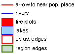
Selected fire occurrence maps, satellite images and a forest fire danger map are prepared daily by the Russian GFMC correspondent Dr. Anatoly Sukhinin, Fire Laboratory of the Sukachev Institute of Forest, Krasnoyarsk, in collaboration with the Emergency Situation Monitoring and Forecasting Agency, Krasnoyarsk branch. The maps are produced on the base of satellite data (classification by the NOAA AVHRR). They show the fire locations (by latitude and longitude) and the area affected by fire (red signature, size in ha). The red arrow at each fire location points to the nearest populated place. The terms Oblast or Kray used in the maps are designations of administrative regions. A map showing the boundaries of administrative regions and a legend is included below.

Map legend
Administrative boundaries
Overview map showing large fire locations detected over the last 10 days
Overview
Latest maps maps showing fire activities of 23 May 2003 (selection)
Kazakhstan Kazakhstan Kazakhstan
For moredetails on fire in Kazakhstan:


