GFMC: Forest Fires in the United States
Forest Fires in the United States
28 March 2003
Latest Satellite Image:
Fires in Southern U.S.
Across the southern United States, the ModerateResolution Imaging Spectroradiometer (MODIS) on the Aquasatellite detected scores of fires burning on 24 March 2003. In theimage, the fires have been marked with red dots. At this time of year, the firescan have a variety of causes. Some are prescribed fires being set by state andfederal land and forest management agencies to reduce fuels in preparation forthe summer wildfire season. A few are wildfires, and others are agriculturalfires being used to clear pasture or farmland. The fires are heavilyconcentrated in Oklahoma (left center), while the fires with the largest smokeplumes are to the east in Arkansas. At bottom center, the Mississippi Riverflows out into the Gulf of Mexico through Louisiana. The high-resolution imageprovided above is 500 meters per pixel. The MODIS Rapid Response System providesthis image at MODIS maximum spatial resolution of 250meters.
Source: NASA/EO
Heat signatures (red) and smoke(light green haze) are visible from fires burning in Arkansas in these MODIS(Moderate Resolution Imaging Spectroradiometer) image from 24 March 2003.
Source: OSEI
The National Interagency Fire Center (NIFC) based in Boise (Idaho) provides key information on current wildland fire situations, related information and background materials. The following information is updated daily and can be accessed directly:
-
State-by-State daily and year-to-date summary of fire activities
http://www.nifc.gov/fireinfo/nfn.html
-
Year-to-date State-by-State total number of wildland fires and area burned (table)
http://www.nifc.gov/fireinfo/nfnmap.html
-
Daily locations of large fires (map)
http://www.nifc.gov/fireinfo/firemap.html
The National Interagency Coordination Center (NICC) provides daily situation reports. These reports include:
-
Incident Management Situation Reports (fires and area burned reported to NICC). The files include current, previous and archived reports
-
Prescribed Fire and Wildland Fire Use (year-to-date fires and area burned reported to NICC, posted weekly on Monday mornings)
http://www.nifc.gov/news/RXWFUYTD.htm
Archived NICC Incident Management Reports (recent daily reports and archived daily reports 1994-1997) are provided by the Center for International Disaster Information (CIDI)
The National Wildfire Information Interagency provides detailed information on each individual state with active fires.
Fire Weather & Fire Danger Information
The Wildland Fire Assessment System (WFAS) is a contribution of “The Fire Behavior Research Work Unit”, Missoula (Montana USA). The broad area component of the Wildland Fire Assessment System (WFAS) generates maps of selected fire weather and fire danger components.
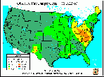
Fire Danger (Potential) is a normalized adjective rating class across different fuel models and station locations. It is based on information provided by local station managers about the primary fuel model, fire danger index selected to reflect staffing level, and climatological class breakpoints. Low danger (Class 1) is green and extreme potential (Class 5) is red.
fire danger (observed time) fire danger (forecasted)
Latest fire dangermap for the United States (observation time) and forecasted fire danger map forthe subsquent day
(Source: WAFS)
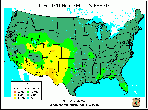
Dead fuel moisture responds solely to ambient environmental conditions and is critical in determining fire potential. Dead fuel moistures are classed by timelag.
10-HR Fuel Moisture 100-HR Fuel Moisture 1000-HR Fuel Moisture
Latest fuel moisture maps for conterminousUS
(Source: WAFS)
The Keetch-Byram Drought Index (KBDI) is a soil/duffdrought index. Factors in the index are maximum daily temperature, dailyprecipitation, antecedent precipitation, and annual precipitation. The indexranges from 0 (no drought) to 800 (extreme drought) (details).
Latest Keetch-Byram drought index map for conterminousUS
(Source: WAFS)
For more Satellite Images displaying recent fires in the US, please visit NASA´SEarth Observatory at:
http://earthobservatory.nasa.gov/NaturalHazards/natural_hazards_v2.php3?topic=fire. EarthObservatory provides MODIS and Landsat Scenes of fires allover the planet.
For more information on the recent fire situation in the US see also: Recent Media Highlights on Fire, Policies, and Politics.
Long-range weather forecasts
National Weather Service
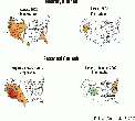
Long-range, 30-day weather forecasts are predicting above-normal temperatures for the southern tier of states from southern California to Florida and throughout the Midwest (see 30 and 90-day forecast maps).
30 and 90-day temperature and precipitation forecast maps(March to May 2003)
(Source: National Weather Service)
For further information see: Wildfire Season Forecast of the Florida Division of Forestry
For further information you may also see to the U.S. Drought Monitor.
For background information on the Southern Area see the Edited Version of the Southern Area Intelligence Briefing Paper for 22 April 2001.


