Forest Fires in the United States: 16 May 2000
Forest Fires in the United States
16 May 2000
The NASA’s Earth Observatory provides freely-accessible new satellite imageries and scientific information about the fires in Los Alamos. On 9 May 2000, the Landsat 7 satellite acquired two images of the area around Los Alamos, New Mexico. These images were acquired from 427 miles in space through its sensor called the Enhanced Thematic Mapper Plus (ETM+). Evident within the imagery is a view of the ongoing Cerro Grande fire near the town of Los Alamos and the Los Alamos National Laboratory.


Fig.1. and 2. Los Alamos fires from Landsat 7; 9 May 2000 (for detailed information and explanations on the images, please have a look on
Los Alamos Fires From Landsat 7
(Source: Earth Observatory, NASA)
Last week, a prescribed fire spread out of control near Los Alamos, New Mexico. Extreme fire behavior with high winds fanned the flames into Los Alamos Canyon on Wednesday, 10 May 2000. The GOES-10 image, acquired on 10 May 2000, shows the effect the 60-mile-per-hour winds had in helping intensify the fire and spread the smoke plume eastward across New Mexico and into northern Texas and the Oklahoma panhandle.
Positioned over the equator, NOAA’s GOES-10 satellite provided this oblique, visible-light perspective on the smoke plume.
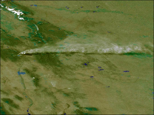
Fig.3. GOES-10 Images Los Alamos Fires, 10 May 2000 (for detailed information and explanations on the images, please have a look on
GOES-10 Images Los Alamos Fires
(Source: Earth Observatory, NASA)
Los Alamos Fires Still Not Under Control
The fire that started after a controlled burn escaped and has burned now 42,000 acres (17,000 hectares). Yesterday, the fire was 28 percent contained, but the weather conditions are too unpredictable to say when it may be brought under control. In Los Alamos, 260 homes have been lost, and the fires threatened buildings at the Los Alamos National Laboratory. More than 1,200 firefighters are working on the icident. On Friday, the 30 day suspension of federal prescribed fires in the American west was announced, and increased levels of approval for such fires are required. Prescribed fires are set under controlled and monitored conditions to remove brush and other undergrowth which can provide fuel for natural fires. National parks and forests require prescribed burns to remove the dry leaf litter. This suspension is being instituted immediately and may be extended beyond the 30 day period. A Fire Investigative Team is on the site to investigate the Los Alamos fire, to find out what went wrong and to determine if the prescribed fire policy and the established procedures are adequate.
The NOAA/AVHRR satellite images of 15 May 2000 reflect the fire situation in New Mexico/Los Alamos as it was highlighted in the GFMC reports during the last days. Heat signature (red) and a smoke plume (light blue) are visible from the large fires burning near Los Alamos. The fire has burned over 44,000 acres (17,806 ha). A second series of heat signatures are visible in New Mexico to the southwest of Los Alamos.

Fig.4. NOAA-15 POES AVHRR HRPT multichannel color composite for New Mexico, 15 May 2000.
(Source: NOAA/OSEI).
A thin smoke plume from the Cerro Grande (Los Alamos) fire is visible in this image. Clouds obscured the smoke in later images.

Fig.5. GOES-8 multichannel color composite for New Mexico, 15 May 2000.
(Source: NOAA/OSEI).
New Mexico’s 4 wildfires at a glance (Source: CNN, 15 May 2000)
Following map and list show details of the four New Mexico’s wildfires that have charred more than 72,900 acres (29,501 ha):

Fig.6. Map of New Mexico – four current wildfires, 15 May 2000.
(Source: CNN)
1. CERRO GRANDE FIRE:
- started 4 May 2000 near Pajarito Mountain in Bandelier National Monument, west of Los Alamos in northern New Mexico.
- caused by a prescribed burn set by the National Park Service.
- 42,232 acres (17,090 ha) burned.
- 28 percent contained.
- aout 25,000 people evacuated from Los Alamos and the community of White Rock. Some Espanola, Abiquiu and Abiquiu Grant residents asked to voluntarily evacuate. White Rock evacuees allowed to return home Sunday afternoon.
- 260 Los Alamos homes and several portable buildings at Los Alamos National Laboratory damaged or destroyed.
- three minor injuries; no release of radiation reported.
- cost of fighting fire $3.7 million.
2. CREE FIRE:
- started 7 May 2000 in Gavilan Canyon at Ruidoso, in southern New Mexico.
- caused by a campfire. Police say three teen-agers have confessed to starting the campfire, and officers are waiting to talk to a fourth suspect who is out of state.
- 8,650 acres (3,500 ha).
- 100 percent contained Sunday night.
- 135 homes evacuated in three Ruidoso subdivisions, some allowed back Thursday. Eight subdivisions, in all, had been evacuated Monday.
- one mobile home burned Sunday along with a home under construction.
- six minor injuries among firefighters and support personnel.
- cost of fighting fire $1.77 million.
3. SCOTT ABLE FIRE:
- started Thursday in Scott Able Canyon about 15 miles south of Cloudcroft, in southern New Mexico.
- caused by a downed power line.
- 20,717 acres (8,383 ha).
- 50 percent contained.
- Towns of Sacramento and Weed plus several nearby canyon enclaves evacuated Thursday.
4. MANUELITAS FIRE:
- started Thursday near Manuelitas, 15 miles north of Las Vegas, in northeast New Mexico.
- cause unknown.
- 1,400 acres (566 ha).
- 90 percent contained
- about 125 evacuations in Manuelitas and Canoncito. Evacuation order has been lifted with a warning for returning residents to use caution.
For further reports regarding to the Los Alamos incident the GFMC would like to refer to the Recent Media Highlights on Fire, Policies, and Politics. Two new reports are pointed out here:
-
Cause of huge Los Alamos fire to be probed (published by Planet Ark, 15 May 2000)
-
Fresh winds stir raging New Mexico fire (published by Planet Ark, 15 May 2000)
Grand Canyon Fire
Another fire that was set as a controlled burn continued to burn out of control over the weekend on the North Rim of the Grand Canyon in Arizona. The fire extended to a 7,000-acre (2,832 ha) wildfire. Possibly a weather front is coming in, which will probably bring more moisture, but also more wind.
Florida
Heat signature (red) and smoke plumes (light blue) are visible from a number of fires burning throughout Florida. Some may be controlled burns.

Fig.7. NOAA-14 POES AVHRR HRPT multichannel color composite for Florida, 15 May 2000.
(Source: NOAA/OSEI).
Wildland Fire Update (15 May 2000) for the United States of America (National Interagency Fire Center (NIFC))
Fire crews were successful in containing two large fires in New Mexico yesterday leaving six large fires burning in Arizona, New Mexico, Florida, and Texas. Fire personnel are securing firelines to prepare for the predicted increased winds throughout the Southwest today and tomorrow. Residents in White Rock, New Mexico, were allowed to return after being evacuated due to threats from the Cerro Grande fire near Los Alamos, New Mexico.
Fire Weather Watches
Fire weather watches are posted for all of New Mexico, except the southeast portion, and northern Arizona, for strong winds and low humidities this afternoon. A fire weather watch is also posted in all of Florida for low relative humidities this afternoon.
The Wildland Fire Assessment System (WFAS) is a contribution of “The Fire Behavior Research Work Unit”, Missoula (Montana USA). The broad area component of the Wildland Fire Assessment System (WFAS) generates maps of selected fire weather and fire danger components. Fire Danger (Potential) is a normalized adjective rating class across different fuel models and station locations. It is based on information provided by local station managers about the primary fuel model, fire danger index selected to reflect staffing level, and climatological class breakpoints. Low danger (class 1) is green and extreme potential (class 5) is red.


Fig. 8.-10. Fire Danger Forecast Maps of the United States and Alaska for 15 May (observation time) and 16 May (forecast) 2000.
(Source: Fire Behavior Research Work Unit, Missoula)
The Keetch-Byram Drought Index (KBDI) is a soil/duff drought index that ranges from 0 (no drought) to 800 (extreme drought) and is based on a soil capacity of 8 inches of water. Factors in the index are maximum daily temperature, daily precipitation, antecedent precipitation, and annual precipitation. KBDI = 0 – 200: Soil moisture and large class fuel moistures are high and do not contribute much to fire intensity. Typical of spring dormant season following winter precipitation. KBDI = 200 – 400: Typical of late spring, early growing season. Lower litter and duff layers are drying and beginning to contribute to fire intensity. KBDI = 400 – 600: Typical of late summer, early fall. Lower litter and duff layers actively contribute to fire intensity and will burn actively. KBDI = 600 – 800: Often associated with more severe drought with increased wildfire occurrence. Intense, deep burning fires with significant downwind spotting can be expected. Live fuels can also be expected to burn actively at these levels.

Fig. 11. Keetch-Byram Drought Index Map of the United States, 15 May 2000
(Source: Fire Behavior Research Work Unit, Missoula)
For further information on the Keetch-Byram Drought Index (KBDI) by Florida’s Division of Forestry / Forest Protection Bureau please refer to Keetch-Byram Drought Index Revisited: Prescribed Fire Applications.
Incident Management Situation Report (15 May 2000)
Current Situation:
Two of the large fires in the Southwest Area are contained. Crews are preparing for a wind event forecast to occur this afternoon and tomorrow. Initial attack activity was reported in the Southwest and Southern Areas. The National Interagency Coordination Center processed orders for airtankers, air attack aircraft, a lead plane, infrared aircraft, engines, a shower unit, radio equipment, meteorological equipment, crews, and miscellaneous overhead. Very high to extreme fire indices were reported in New Mexico, Arizona, Texas, California, Utah, Oklahoma, and Maryland.
On 13 May, Interior Secretary Bruce Babbitt and Agriculture Secretary Dan Glickman announced a 30-day suspension of all federal prescribed fires
west of the 100th meridian. For more information, see the U.S. Forest Service Fire web page at www.fs.fed.us/fire/news.shtml.
Outlook:
A fire weather watch is posted in all of New Mexico except the southeast portion for strong winds and high haines indices this afternoon.
A fire weather watch is posted in all of northern Arizona for strong winds and low relative humidities this afternoon.
A fire weather watch is posted in all of Florida for low relative humidities this afternoon.
New Mexico will be windy and warmer. Afternoon winds will be southwest to west at 20 to 30 mph and gusty. High temperatures will be in the 80’s to lower 90’s. Minimum relative humidities will be 7 to 17 percent.
Arizona will be mostly sunny and windy. Winds will be southwest at 20 to 40 mph. High temperatures will be in the 70’s in the mountains and up to 100 in the southern deserts. Minimum relative humidities will be 5 to 17 percent.
Florida will be mostly clear with north winds at 10 to 15 mph. High temperatures will be 85 to 90. Afternoon relative humidities will be near 20 percent.
West Texas will be mostly sunny and locally breezy. Winds will be southwest at 10 to 25 mph. High temperatures will range from the upper 80’s to mid 90’s in most of the state, and up to 109 along the Rio Grande River.
Long-range, 30-day weather forecasts are predicting above-normal temperatures and below-normal precipitation for the southern tier of states from southern California to Florida and throughout the Midwest (see 30 and 90-day forecast maps).
Tab.1. Five-Year Wildland Fire Comparison Statistics Year-to-Date for the United States (13 May 2000)
(Source: National Interagency Fire Center (NIFC)
As of 05/13/00 Number of Wildland Fires Area burnt Acres Hectars 2000 33,535 851,209 344,472 1999 34,928 667,699 270,208 1998 17,721 290,396 117,519 1997 23,988 379,773 153,688 1996 51,321 1,349,890 546,281

Fig. 12. 30 and 90-day temperature and precipitation forecast maps (May and May to July 2000)
(Source: National Weather Service, Boise, Idaho)
Remarks on Prescribed Burning
At this time of the year prescribed burning operations are conducted routinely.
Fire is an important natural tool for ecosystem management. It can reduce dense vegetation improving wildlife habitat and lessening the potential for large, wildfire disasters. Land managers are directed to prepare a prescribed fire/burn plan for every area of public land that can burn. Some areas require total suppression while others will benefit from a wildland fire. Those areas that will benefit from a fire can be treated by a prescribed fire.
Especially, for the moment, in the southern and southeastern regions of the United States prescribed fire activities will be carried out in the following weeks and months. In this case, fire signals on satellite images can be traced back to this kind of land management activities.
In the Prescribed Fire Position Paper of the Forest Protection Bureau by the Division of Forestry in Florida, prescribed fire activity is described as a land management application that is essential to the practice of forestry, management of wildlife, preservation of endangered plant and animal species, improvement of range conditions and reduction of wildfire damage in the wildland/urban interface areas. While there is general public and landowner concern with increased smoke, reduced air quality, and liability; the general public and landowners benefit significantly from the reduction of devastating wildfire, improved wildlife habitat and forage, preservation of endangered and threatened plant and animal species, and improved management of forest resources. The prospect of severe reductions in the utilization of this management tool is of major concern to Florida’s natural resource managers and conservationists due to the subsequent loss of derived public and private benefits. They suggest the need for legislative attention.
Another report on nation-wide prescribed burning in the U.S.A. was published in International Forest Fire News No.19 (September 1998).
A set of photographic documents on prescribed burning techniques and objectives in the Southeast can be visited in our photo archive.
