Forest Fires in Southern and Northern United States: 25 May 1999
Forest Fires in Southern and Northern United States
25 May 1999
Several active fire signals are recorded by OSEI on 24 May 1999 in Florida an in the northwestern United States.
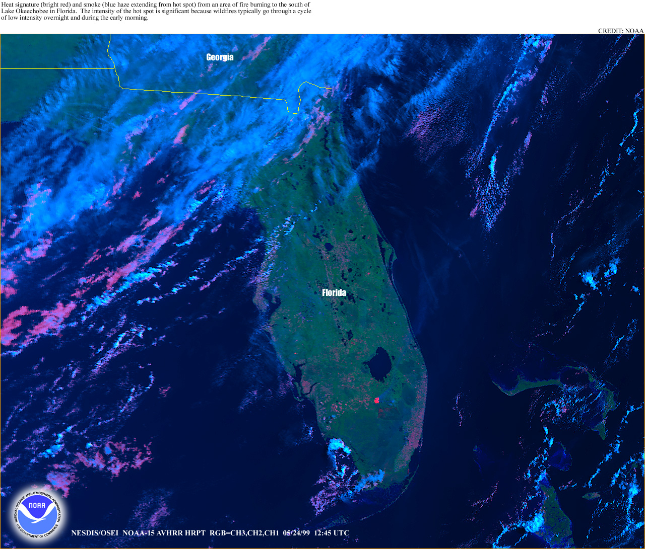


Fig.1., 2. and 3. The NOAA AVHRR image shows heat signatures and smoke plumes from areas of fire burning in Florida on 24 May 1999. Red color of some bodies of water is due to solar reflection saturating the AVHRR in band 3.
(Source: NOAA http://www.osei.noaa.gov/)

Fig.4. The NOAA GOES image shows also heat signatures (bright white spots) from areas of fire burning in Florida. With the green lines, the borders of the counties were marked. The hot spot to the north is in Baker County and the southern hot spot is on the border of Hendry (west) and Palm Beach (east) counties.
(Source: NOAA http://www.osei.noaa.gov/)

Fig.5. The NOAA AVHRR image shows heat signatures and smoke plumes from areas of fire burning in the northwestern United States and in British Columbia, Canada.
(Source: NOAA http://www.osei.noaa.gov/)
The DAILY FLORIDA WILDFIRE STATUS SYNOPSIS of Monday, 24 May 1999, prepared by the Florida Department of Agriculture and Consumer Services, Division of Forestry in conjunction with the National Forests in Florida is stating, 104 wildfires burned 3,457 acres (1,398 ha) on Sunday. The year-to-date statistic increased meanwhile to 3,611 wildfires, which burned 274,581 acres (111,119 ha). For information regarding this report please refer to the detailed synopsis, which can be accessed under http://flame.doacs.state.fl.us/Suppress/dfu/May5.html.
The INCIDENT MANAGEMENT SITUATION REPORT (http://www.nifc.gov/news/sitreprt.html) from 20 May 1999 can be quoted as follows:
“…
CURRENT SITUATION:
Moderate initial attack activity was reported in the Southern and Southwest Areas, with minimal initial attack fire activity being reported elsewhere. Mobilization of resources through the National Interagency Coordination Center included a caterer, shower, helicopters, airtankers and miscellaneous overhead. Very high and extreme fire indices were reported in Arizona, Texas and New Mexico.
SOUTHERN AREA LARGE FIRES:
FRIENDLY, Osceola National Forest. A Type II Incident Management Team (Owen) and Unified Command (Ferguson) are assigned. This fire is located within the Pinhook Swamp. The fire continued to spread in the inaccessible area of the swamp. Ground forces are being assembled to control the fire as it approaches the uplands.
BAY CREEK, Apalachicola National Forest. This fire is located in Liberty County. The fire is burning in heavy fuels in a inaccessible area.
NORTHERN CALIFORNIA LARGE FIRES:
BELL WEST, Modoc National Forest. A Type II Incident Management Team (Weltch) is assigned. This fire is located thirty miles west of Canby. The team received a briefing last night and will set up the Incident Command Post today.
OUTLOOK:
Florida will be partly cloudy with scattered afternoon thunderstorms. High temperatures in the mid 80’s to near 90 with minimum humidities 45-60%.
Northern California will be sunny with increasing afternoon clouds. Winds will be 4-18 MPH. High temperatures will be in the upper 70’s to upper 80’s.
Southern California will be mostly sunny. Minimum humidities will be 25-40% in the mountains and 15-25% in the valleys. High temperatures will range from the 60’s in the mountains to near 70 in the valleys.
New Mexico will be partly cloudy with scattered afternoon and evening thunderstorms. Minimum humidities will range from 15-25%, except 30-40% in the east, central and northeast plains. High temperatures will be in the 60’s and 70’s in the mountains and north, with 80’s in the lower elevations in the south.
West Texas will be mostly sunny. Minimum humidities will be 35-45%. High temperatures will be in the 80’s.
Alaska will be mostly sunny. Minimum humidities will be 20-40% in the interior. High temperatures will be in the 50’s along the coast with 60’s in the interior.
