Meteorological Conditions in South East Asia: 7 March 2000
Meteorological Conditions in SouthEast Asia
7 March 2000
The Meteorological Service of Singapore reports on 7 March 2000 for the South East Asian region: “Hot spots were observed mainly in central Sumatra and Borneo. Smoke haze was also observed over central Sumatra.” Forecasts of winds and surface pressure are also available.

Fig. 1. Regional Surface Winds and Haze/Hot Spot Map, 7 March 2000
(Source: Meteorological Service of Singapore)
The latest NOAA14 satellite image show “High Temperature Events, HTE” (hot spots) and smoke in Sumatra and Borneo. HTE’s can be identified as red dots.


Fig.2. & 3. Latest NOAA Satellite images of Sumatra and Borneo, 7 March 2000
(Source: Meteorological Service of Singapore)
PlanetArk posted the following article today: Sumatra smog at hazardous level, emergency urged
INDONESIA: March 7, 2000
JAKARTA – Smog from forest fires raging in Sumatra has passed hazardous levels, and officials said yesterday a government agency had called for a state of emergency to be declared. Neighbouring Singapore reported slightly hazy conditions on Monday, while Malaysia said it had no haze. Muhammad Alamsyah, head of the Sumatra Environmental Supervising Body, said schools were opening late, children were being kept indoors and supplies of essential smoke masks were running out. “The pollution level has passed 300 in Pekanbaru and around the Caltex oil well. Protection masks should be a ‘must-worn’ during this condition,” he said. A reading higher than 300 on Indonesia’s Air Pollutant Standard index is regarded as ‘hazardous’. Normal, healthy air has a rate below 50.
Khodijah Nurhadi, another official at the agency, said the body had recommended a state of emergency around Pekanbaru, located some 935 km (581 miles) northwest of Jakarta. “The air condition has been like this since March 1. We have suggested the government to declare that Pekanbaru is in a state of emergency,” he said. In recent years, smog from fires around the oil town of Pekanbaru, capital of Indonesia’s Riau province, has repeatedly drifted over neighbouring Singapore. In 1997 smog from fires in Sumatra and Borneo blanketed much of southeast Asia for weeks. Much of the blame was placed on plantation firms using fire to illegally clear land.
HOT SPOTS
Alamsyah that said as of Monday 212 fire hotspots had been located in Riau. The smog was strongest in the mornings and normally began to clear after 9 a.m. The smog levels were not as bad as in 1997, he said. The Singapore government said favourable wind conditions would spare Singapore from the worst of the smoke haze coming out of fires in central Sumatra. “The forecast of low-level winds over Singapore are likely to change from the current westerly to north-westerly in the next few days and hence only a small portion of the smoke haze generated is likely to be carried over to Singapore,” a joint statement from the Meteorological Service Singapore and the Ministry of the Environment said. It said the pollution level in Singapore was in the “moderate” range – that is, slightly hazy – with the 24-hour Pollutant Standards Index (PSI) measuring air quality at 53 at 4 p.m. (0800 GMT). From zero to 50 is considered good, 51 to 100 moderate, 101 to 200 unhealthy, 201 and above, very unhealthy. Rosnani Ibarahim, director-general of Malaysia’s Department of Environment, told Reuters the air quality in Malaysia was “good” and there was no haze. Noting the fires on Sumatra, she said: “We are monitoring the situation quite closely.” She said the winds currently were blowing away from Malaysia but in June the winds typically turned southwesterly, and “if the fires persist until then, we will begin to feel the effects of the haze”.
REUTERS NEWS SERVICE
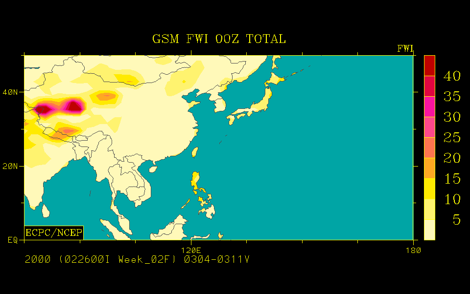
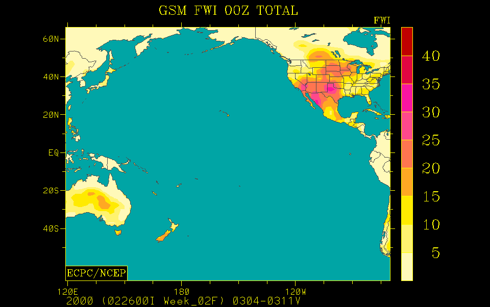
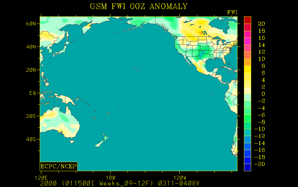
The GFMC displays selected and daily updated global and Asia-Pacific Experimental Climate Prediction Center (ECPC) Fire Weather Forecasts (Fig.2-7). These examples allow a quicklook and provide daily and weekly total forecasts, and forecasted monthly anomalies (for next month). For background information refer to the ECPC products description page.
today not available

today not available
tomorrow this week this month
Fig.4.-9. Fire Weather Index (FWI) forecast for tomorrow (left), this week (center) and the predicted FWI anomaly for this month (right) for the Western Pacific and the Pacific Ocean. The daily forecast refers to 12:00 hrs noon UTC (Greenwich) time; the weekly total forecast and the monthly forecasted anomaly refer to 00:00 hrs UTC, which is local noon at dateline (180° longitude). Forecast time is 12:00 hrs noon UTC (Greenwich) corresponding to local evening time in mainland and insular SE Asia (updated: 2 March 2000).
(Source: ECPC)
The ASEAN Fire Weather Information System (ASFWIS) is a co-operation between ASEAN and the Canadian Forest Service. It provides maps describing the current fire weather situation in South East Asia. This system is based upon the Canadian Forest Fire Danger Rating System (CFFDRS) (for further infomation to the CFFDRS refer to ASFWIS). Studies have shown that the CFFDRS is applicable outside of Canada. Currently it is also used in a modified form in New Zealand (see References). In New Zealand the Fire Weather Indices Fine Fuel Moisture Code (FFMC) and the Initial Spread Index (ISI) represent the fire danger in the scrublands. The Duff Moisture Code (DMC) is also applicable in South East Asia, because it potentially describes the moisture state of the upper peat layers in peat and peat swamp forests. All three parameters may serve as a suitable indicator of forest fire danger in South East Asia.
According to the ASFWIS for 7 March 2000 these parameters show various fire weather conditions over South East Asia.


Fine Fuel Moisture Code
Duff Moisture Code
Drought Code


Initial Spread Index
Buildup Index
Fire Weather Index
Fig.10.-15. Output maps of the ASFWIS, 7 March 2000
(Source: ASFWIS)
The ASEAN Haze Action Online provides the following information:
- Monitoring: Hyperlinks to institutions involved in regional monitoring and prediction of fire and smoke haze
- Haze News: ASEAN Transboundary Haze Update (updated daily)
- Intranet: Information and possible participation in the ASEAN Haze Action Online Intranet Information Services (for associated registered participants)
- Mobilization Plan: Model Fire Suppression Mobilization Plan
- Inventory: Inventory and analysis of forest and land fire suppression capabilities
- Haze Forum: Communication platform on fire and smoke-haze issues in the ASEAN region
- Calendar: Fire and haze-related events can be identified by a search modus
The Forest Fire Prevention and Control Project (FFPCP) in Palembang (Sumatra) provides a fire overview map for the 3 March 2000.

Fig.16. Fire Overview Map for 6 March 2000 of the FFPCP project in Palembang.
(Source: FFPCP)
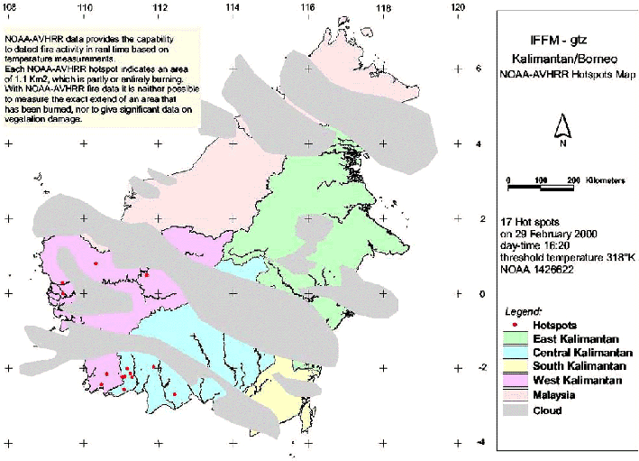
The last available fire overview map (29 February 2000) of the Integrated Forest Fire Management (IFFM) project in Kalimantan shows 17 HTE’s (hot spots).
The Indonesian Meteorological Agency Badan Meteorologi dan Geofisika publishs the Indonesia Daily Forecasting for 7 March 2000. For the representative selected areas metereological data are provided as follows:
Palembang Samarinda Bandung Weather condition rain rain rain Temperature (min – max °C) 26 – 33 26 – 30 20 – 27 Humidity (min – max %) 52 – 95 73 – 88 60 – 90
Summary: Although the current fire weather conditions do under normal conditions not favour extensive land clearing by fire or escaping wildfires in Indonesia, the consequences of the large wildfires of 1997-98 must been taken into consideration. These fires had caused extensive degradation of primary and secondary forests along with the spreading of “alang-alang” (Imperata cylindrica) grasslands. These grasslands facilitate the spread of uncontrolled fires over large areas.
See also the IFFN Country Notes.
