California’s super-dry February raises specter of early fires and drawn-down reservoirs
28 February 2020
Published by https://www.latimes.com
USA – California is set to conclude one of its driest Februaries in recorded history, elevating fears the state’s always-unpredictable fire season could arrive early this year — if March doesn’t provide some wet relief.
February is typically a prime month for Pacific storms to produce much of the Sierra Nevada snowpack — moisture that sustains wildlife, delays wildfire season and serves as a water bank for thirsty cities and farms. But those storms didn’t arrive in February, with a state survey Thursday showing the snowpack was 46% of average.
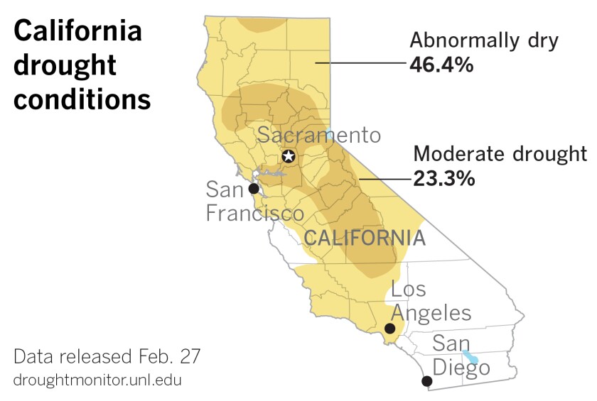
After an unusually wet winter last year, many of California’s reservoirs are well above their season average, so state water managers have few fears about near-term shortages. Yet if the coming months remain relatively dry, the state will be dependent on an uncertain future to prevent the state from swinging back into drought conditions.
“All it takes is an extreme atmospheric river to end up in a high-water situation even if the broader season is dry,” said state hydrologist Michael Anderson, who added that a storm is expected to hit the state in the next couple of weeks. “The two extremes can now coexist in a warmer climate.”
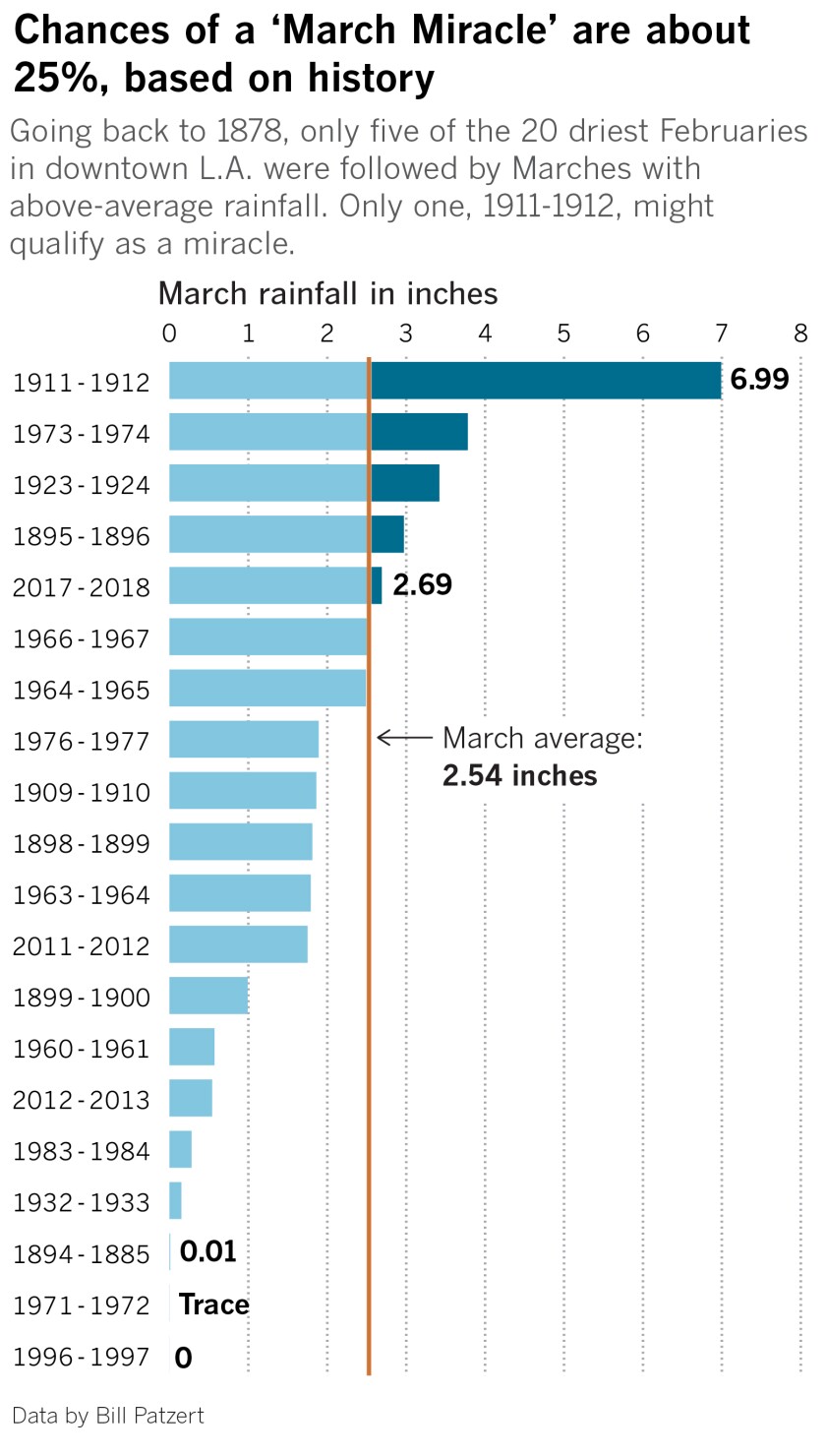
Historical data, however, suggests there is just a small likelihood of what some call a “March Miracle.”
(Paul Duginski / Los Angeles Times)
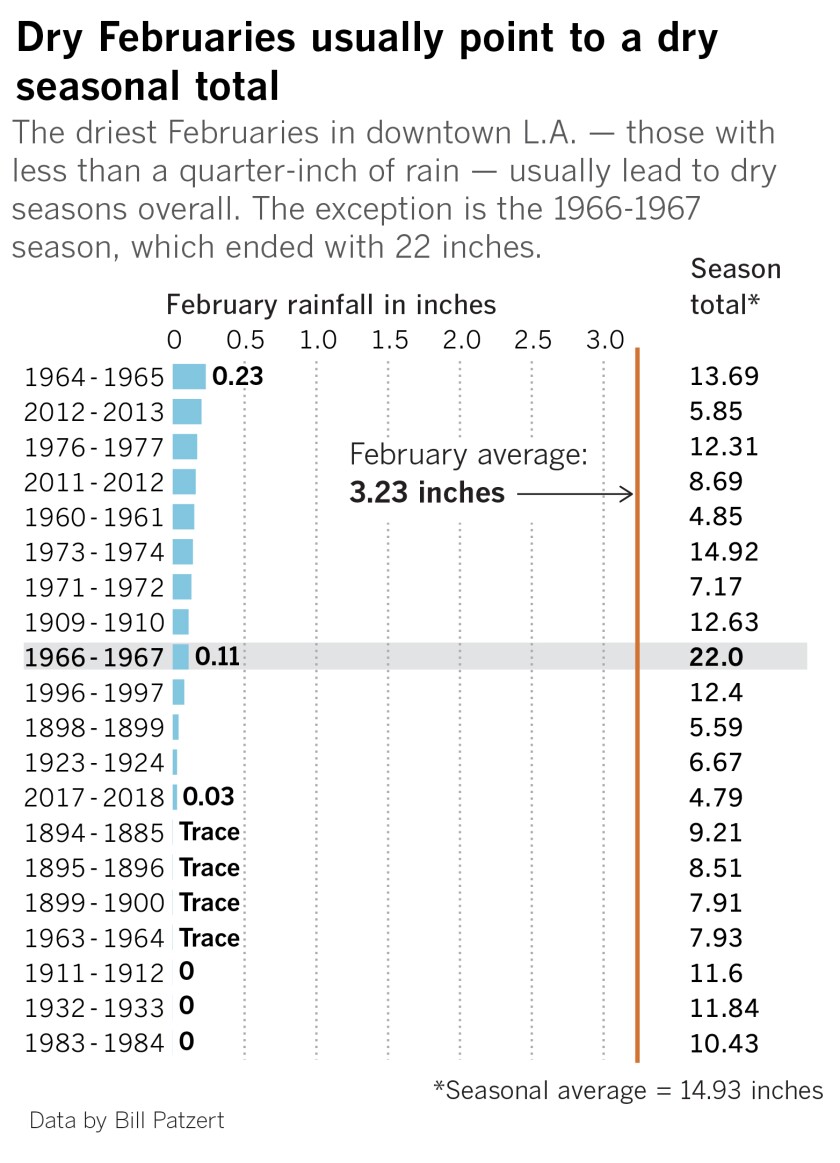
Over the last 14 decades, only five of the 20 driest Februaries in downtown Los Angeles were followed by Marches with above-average rainfall, said Bill Patzert, a retired climatologist for the Jet Propulsion Laboratory in La Cañada-Flintridge. San Francisco follows a similar pattern, with only six of 18 relatively dry Februaries leading to above-average March rainfall since 1852, said Jan Null, a meteorologist with Golden Gate Weather Services.
“You’re running out of time,” said meteorologist David Miskus, who authored the federal government’s most recent U.S. Drought Monitor report on Thursday. “It’d be nice to get a near-normal March, but it looks like you might have to wait until next season.”
For now, the effects of the dry February can be seen from space — in satellite photos that capture the barren Sierra, and at the region’s ski resorts, desperate for fresh powder. They also can be seen across the state’s ranch lands — where cattle seeking fields of green grass shoots are finding dust instead.
(Paul Duginski / Los Angeles Times)
It has not rained at all in downtown Sacramento in February, making it the driest February on record there in 153 years of record-keeping. The second-driest February was in 1899, when it rained four-tenths of an inch. Though it did rain there in January, it amounted to less than half the monthly average.
The lack of rain has also meant fewer clouds, which can act as insulation for the region. Without them, February’s average high temperature was 67.6 degrees, or more than 6 degrees warmer than normal for the month, said National Weather Service meteorologist Eric Kurth. Conversely, fewer clouds have also made it colder than average at night.
The situation is similar in San Francisco, where the city’s downtown hasn’t had any measurable precipitation since late January, marking one of the longest streaks of dry winter days since the peak of the drought in 2015.
“It seems like you guys either get feast or famine,” Miskus said from his Maryland office. “I guess the normal is to be abnormal.”
Because of the enduring dryness, Cal fire will probably begin staffing its seasonal firefighters and inmate hand crews earlier than last year, when an exceptionally soggy winter was capped with a surprise storm in May, said Mike Mohler, spokesman for the California Department of Forestry and Fire Protection.
A new slate of fuel-reduction and fire break projects are lined up for 2020 to continue last year’s surge of work aimed at protecting rural communities and evacuation routes.
(Paul Duginski / Los Angeles Times)
“It’s a double-edged sword — lots of rain, lots of brush; no rain, dry brush,” Mohler said. “We hate to preach doom and gloom, but it’s the reality we live in.”
The writing of what could come is already on the wall, Mohler said. A six-acre brush fire broke out at San Bruno Mountain State and County Park south of San Francisco on Friday, the smoldering remnants of a prescribed fire in Mendocino County grew out of control earlier this week, and there was a 100-acre fire near Lake Tahoe in mid-February.
After back-to-back catastrophic fire years, 2019 ended up being the quietest year of wildfires in California since 2011, possibly because the state’s largest utilities proactively shut down their power lines most vulnerable to wind events. The strategy triggered blackouts for millions of customers but also potentially prevented some blazes from igniting during high winds.
In Southern California, where the fire season typically begins at the end of summer, the uneventful winter just gives the landscape that much more time to dry out, officials said. When the month is over, this February will probably rank as the 10th-driest on record for downtown Los Angeles, said meteorologist Joe Sirard of the National Weather Service.
Though a small storm is forecast for the first week of March, experts say it’s nowhere near big enough to make up for the our liquid deficit.
Patzert says our water deficit and drought goes back further than people think, evidenced by many of California’s groundwater wells. He pointed to the the Baldwin Park Key Well in the San Gabriel Valley Municipal Water District, which hit an all-time low in 2018 and remains below its historic average.
Based on the 143 years of records available, Patzert says the wet winters of 2016-17 and 2018-19 were the exceptions, not the rule, for California’s rain future.
Over that time frame, the average annual rainfall in downtown Los Angeles has been 14.93 inches. Based on that average, the 20-year period from 1999 to 2019 was more than 2 inches below that.
Another disturbing trend is earlier melt-off of Sierra snow. California’s snowpack melted an inch just in February because of warmer-than-typical weather, officials said.
“What we see in California is the snowpack comes later, it leaves earlier,” Patzert said. “We shifted the seasons. Warmer falls, warmer springs. And so droughts are now hotter. They’re normal, but they’re hotter.”
