Mongolia: Forest and Steppe Fire Monitoring in Mongolia Using Satellite Remote Sensing (IFFN No. 21 – September 1999)
Forest and Steppe Fire Monitoring in Mongolia Using Satellite Remote Sensing
(IFFN No. 21 – September 1999, p 71-74)
Introduction
Mongolia is a country located in a Central Asian highland with an area of 1,565,000 km2 and a population of 2.3 million, which makes Mongolia one of the least populated countries in the world. The country borders Russia in the North and China in the South. Mongolia is located deep within the interior of the Eurasian mainland far from seas and oceans, is a highland country, and has a markedly continental climate with poor soil fertility, scanty surface water resources, and harsh natural conditions.
Forests and grasslands play an important role in the economic development of the country. Forest covers 10% and grassland 70% of all territory. Mongolian nature and geography, its economic and social features account for its considerable vulnerability to natural disasters. Winters are often very cold, springs are difficult with blizzards, tornadoes and regular wildfires. Heavy rains and floods occur in summers and in autumn heavy snowfalls, frosts and blizzards are common. This means that throughout the year the country is under the pressure from some of these natural disasters.
Some of the disaster experts have estimated the disaster proneness based on the number of human losses. Most of them do not include such natural hazards, like heavy snowfall, drought, or wildfires to disasters unless there are not so many human deaths. But in the case of Mongolia, such hazards cause directly and indirectly much more losses to the livestock and, also damage to the environment. Animal husbandry is one of the most important sectors in the Mongolian economy and still is the basis of our living conditions. This is why meteorological hazardous phenomena and wildfires, which are affecting on pasture conditions, have such a negative influence on Mongolian development as a whole.
Satellite Remote Sensing in Wildfire Disaster Monitoring
There are several satellites for monitoring of natural resources, which have been used also in studies on wildfires over the world. In the beginning of the 1970s, American researchers have studied forest fire mapping and inventory by using Multi-Spectral Scanner (MSS) imagery on board of Landsat satellite series.
The Geostationary Operational Environmental Satellite (GOES) is part of a network of geosynchronous orbiters designed to provide meteorological observations for the entire world. Besides its usefulness in monitoring and measuring cloudiness, GOES have been used to detect large-scale fires indirectly by the identification of smoke plumes
Also, European Resource Satellite ERS-1, American Defence Meteorological Satellite Program (DMSP), Japanese JERS-1, and National Ocean and Atmospheric Administration (NOAA) series satellites are used for vegetation fire studies.
Of the above-mentioned earth resources satellites, the NOAA series satellite is the most suitable for monitoring after the rapid development of natural disasters, such as wildfires, floods, meteorological phenomena, and so on.
The current sequence of NOAA satellites has been in continuous operation since 1978. There are four major advantages of using NOAA series satellites for fire detection and fuel mapping (early warning).
-
Spectral Resolution. The AVHRR (Advanced Very High-Resolution Radiometer) sensor onboard of NOAA satellite acquires data in 5 spectral channels. The Spectral location of Channel 3 (3.55-3.93 (m), coincides with the radiation of maximum intensity from a black body with a temperature 780 to 800K, and is therefore well suited to the detection of elevated heat sources, which indicate the presence of active fires. Channels 4 and 5 (near infrared channels) are located in the thermal infrared part of the electromagnetic spectrum where all radiation is emitted by the earth surface according to its temperature and radiation and used for estimation of cloudiness, cold surface of the earth. Channels 1 and 2 are invisible and near-infrared parts of the electromagnetic spectrum where all radiation is reflected sunlight and widely used for estimation of vegetation cover.
-
Spatial Resolution. The resolution of AVHRR data is 1.1 square kilometers. Although the resolution is rather low, due to the very high sensitivity of the channel-3 to the hot sources, even 50m long fire fronts can be detected in the steppe. Full (1.1 km) and lower resolution (4 km) data can be recorded and transmitted directly from the satellite in the High-Resolution Picture Transmission (HRPT) for selected areas of the world within a radius of 2500 km from a receiving station.
-
Frequent temporal coverage. Currently, there are 2 NOAA satellites in complementary near-polar orbits, NOAA-12 and NOAA-14, one crossing over Mongolia at local solar times of approximately 07:30 and 19:30, and the other at 02:30 and 14:30. The orbital characteristics are such that with two satellites in operation, the possibility exists for twice daily and twice nightly coverage at any point in Mongolia.
-
Overpass time. The current afternoon, approximately 14:30 overpass time of NOAA-14 is the best available in terms of fire detection and monitoring in Mongolia
Fire damage of the last three years in Mongolia
Forests and grasslands play an important role in the economic development of the country. Forest cover is 12.5 million ha or 8.1% of the Mongolian territory. Forests consist mostly of larch, pine, birch, cedar, spruce, and saxauls (Haloxylon ammodendron). Grassland covers 70% of all territory. During the last few years, Mongolia has experienced various natural or non-natural hazards and of them, one of the most dangerous is Forest and steppe fires.
In an average year, 50-60 forest fires and 80-100 steppe fires occur, annually. About 95 percent of steppe and forest fires in Mongolia are caused by human activities. Although humans cause most fires, nature has the burning materials.
Winters and springs from 1996 to 1998 were extremely dry and were lacking of snow in most areas. From late February to early June, Mongolia suffered from large-scale forest and steppe fires that devastated large parts of the country. Fire damage data are given in Table 1.
Tab.1. Fire damages in Mongolia 1996-98

Casualties
29 people died, 82 people had different kinds of injuries, and 11,700 livestock died, 218 family houses, 1066 communication facilities, 750 fences, 26.3 million ha pasture, and forest burned. The total cost of the property 820.2 million MN¥ (Mongolian Tugrig). Ecological and economical damage estimated as 1,850.5 million MN¥.
According to the statistics since 1963, we can see that the frequency of forest and steppe fires has increased (Fig.1).

Fig.1. Number of fires and area burned in Mongolia 1963-1997
The methodology of fire detection and main results of fire disaster monitoring
Since the establishment of the NOAA satellite receiving station at the National Remote Sensing Center of Mongolia, in 1987, the staff of the Center has developed and tested technologies for natural disaster monitoring, such as forest and steppe fire, drought, floods, meteorological phenomena, etc.
Recent fire danger situations in forest and steppe zones challenged staff of the National Remote Sensing Center to test and improve their operational technology to quickly process and transfer data containing burning sites to disaster-related and administrative organizations. In the last three years, 788 fires were detected primarily by satellite data and thus millions of money were saved. The accuracy of detected hot spots as a fire is estimated as 76.9 % of the total number of cases in the last five years.
Figure 2 shows an example of grassland fire dynamics from 27 March to 7 April 1998, on the territory of Dashbalbar village, Dornod Province, the northeastern part of Mongolia near the border with Russia. A total of 984,000 hectares of grassland was burnt in this incident.
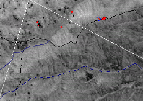
27 March 1998

29 March 1998

30 March 1998

1 April 1998

7 April 1998

Total burned area: 983893.85ha
Fig.2. Steppe fire dynamics in spring 1998, Dashbalbar county of Dornod Province, Mongolia, as depicted by NOAA-AVHRR.
Figure 3 shows the burnt areas of Mongolia in fire seasons of 1996, 1997, and 1998.


Fig.3. Burnt area maps of Mongolia for the years 1996, 1997 and 1998
Figure 4 shows a total fire frequency map in the last 3 years (burnt areas in one year shown in pink, 2 times burnt in 2 years in purple, and areas burnt each year in 3 years in red).

Fig.4. Fire frequency map of Mongolia for the period 1996-1998
In the last three years, a total of 21,207,464 ha of land was burnt and 75.4% of the total area burned only in one year, 20.5% of the area burnt in each of the two years, and 4.1% burnt in all 3 years.
The burned land area, based on the land cover map obtained from NOAA/AVHRR seasonal data of 1997. The total area of grassland is 78,266,382 ha. The vegetation type most affected by annual fires is grassland.
Conclusions
-
Development of space technology and its application, integrated use of Geographic Information System (GIS) has provided a new method for natural resource management, natural disaster monitoring, which has received great attention because of their wide view, high observation frequency, and low cost. It is especially sound in the Mongolian context, as a developing country, if we consider the country’s specific conditions: sparse population, vast area, and bad development of infrastructures such as communication and road systems.
-
Development of the above-mentioned technologies requires a lot of mental and physical investment, and Remote Sensing and GIS technology should be wider introduced for all decision-making systems to ensure human safety, health, environmental protection, and sustainable development of the countries in the world.
N. Erdenesaikhan
Ministry of Nature and the Environment
Government Building No. 3
Baga Toiruu-44
Ulaanbaatar-11
MONGOLIA
Fax: ++976-1-321401
Tel: ++976-1-312269
e-mail: Baigyam@magicnet.mn
and
Ms. M. Erdenetuya
Researcher
National Remote Sensing Center
Khudaldaany street-5
Ulaanbaatar-11
MONGOLIA
Fax: ++976-1-321401
Tel: ++976-1-329984
e-mail: mtt@magicnet.mn
