GFMC: Forest Fires in the Russian Federation
Forest Fires in the Russian Federation
27 September 2010
GFMC analysis: According to the latest satellite-derived analysis provided by the Sukachev Institute for Forest and Emercom (using the NOAA AVHRR satellite data) and the Institute of Space Research of the Russian Academy of Sciences (using the MODIS satellite data) the total area burned by 18 August 2010 in the Russian Federation is:
NOAA AVHRR: 5.9 million ha
MODIS: 5.8 million ha
Note: The area burned includes all vegetation types (forest and non-forested land on the whole territory of the Russian Federation, including territories in which fires are monitored only but not controlled). This explains the discrepancy of fire statistics published by various government sources, which exclusively refer to forests under fire protection (see FAO Regional Fire Report Central Asia Region).
Note: Both, data and fire situation reports of Avialesookhrana from the National Forest Fire Centre of Russia as well as from Fire Laboratory of theSukachev Institute of Forest, Krasnoyarsk are temporarily not available due to correction of satellite algorithms.
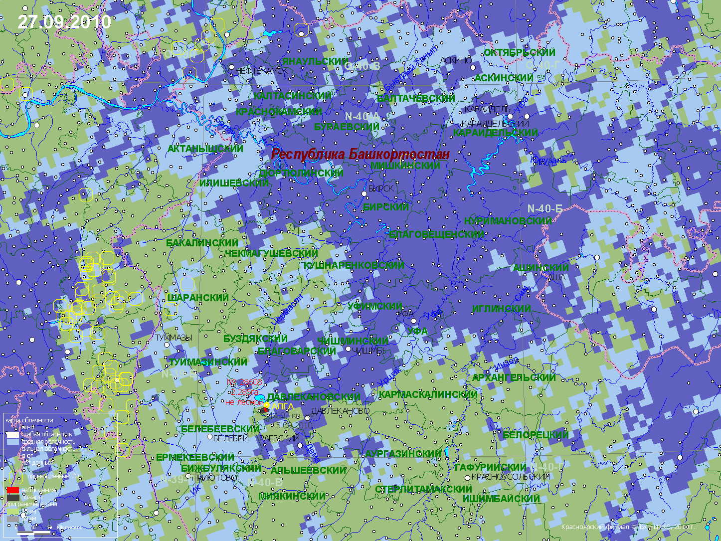
Fire danger map for 27 September:

Source: Sukachev Institute for Forest, Krasnoyarsk
Avialesookhrana from the National Forest Fire Centre of Russia provides up-to-date NOAA images for the whole of the Russian Federation and neighbour territories. The Space Monitoring Information Support Laboratory provides extensive links to sites with satellite imagery for the Russian Federation, meteorological information as well as fire related images are accessible.
The NOAA AVHRR satellite image composite shows fire activities in the Russian Federation.

Latest (27 September 2010 09:00 GMT) NOAA 12&14 AVHRR composite
The red squares indicate regions of active fires (MODIS Detection). For details the GFMC readers are encouraged to use the hyperlinks provided by Avialesookhrana, the Aerial Forest Fire Protection Service of the Federal Forest service of Russia.
(Source: Avialesookhrana cloudiness maps)
Eurasian Experimental Fire Weather Information System
The system has been developed by forest fire researchers from Canada, Russia and Germany is displayed on this website starting 18 July 2001. Complete information and a set of daily fire weather and fire behaviour potential maps covering Eurasia (the Baltic Region, Eastern Europe, countries of the Commonwealth of Independent States, Mongolia) can be accessed at:
https://gfmc.online/fwf/eurasia1.html
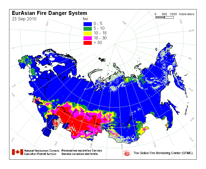
Example of the Eurasian Experimental Fire Weather Information System:
Latest map of the Experimental Fire Weather Index (FWI) for Russia and neighbouring countries
Daily Fire Occurrence and Fire Danger Maps of the Fire Laboratory of the Sukachev Institute of Forest, Krasnoyarsk
Selected fire occurrence maps, satellite images and a forest fire danger map are prepared daily by the Russian GFMC correspondent Dr. Anatoly Sukhinin, Fire Laboratory of the Sukachev Institute of Forest, Krasnoyarsk, in collaboration with the Emergency Situation Monitoring and Forecasting Agency, Krasnoyarsk branch. The maps are produced on the base of satellite data (classification by the NOAA AVHRR). They show the fire locations (by latitude and longitude) and the area affected by fire (red signature, size in ha). The red arrow at each fire location points to the nearest populated place. The terms Oblast or Kray used in the maps are designations of administrative regions. A map showing the boundaries of administrative regions and a legend is included below.


Map legend
Administrative boundaries
Latest maps maps showing fire activities of 27 September 2010 (selection):
Overview map showing large fire locations detected over the last 10 days:

Overview
Latest maps maps showing fire activities of 27 September2010 (selection):


Khakass RepublicKrasnodar KrayYamal-Nenets Autonomous Area/Okrug
More maps of other regions are available on request: info@gfmc.org
For more details on fire in the Russian Federation:
- Regional Central Asia Wildland Fire Network
- International Conference on Cross-Border Forest Fires and Cooperation in their Suppression (hosted by Russia and supported by GFMC, June 2010)
- Report of the Seminar Wildfires and Human Security: fire Management on Terrain contaminated by Radioactivity, Unexploded Ordnance and Land Mines (Kiev / Chernobyl, Ukraine, 6-8 October 2009) (PDF, 0.1 MB)
- Chernobyl Resolution on Wildfires and Human Security: Challenges and Priorities for Action to address Problems of Wildfires burning on Terrain Contaminated by Radioactivity, Unexploded Ordnance (UXO) and Land Mines (PDF, 52 KB)
- IFFN Russian Federation Special Issue (IFFN 32)
- Russia 2002 fire report
- IFFN Russian Federation 2002 Fire Special (IFFN 28)
- IFFN Reports from Russia
- Fire Research Campaign Asia-North (FIRESCAN)
Bibliography on fire in ecosystems of boreal Eurasia:
One of the results of the first international fire science conference in the Russian Federation (1993) was the publication of a monograph on fire in boreal Eurasia, including some selected contributions on boreal North America. The literature cited in the monograph contains numerous publications which in many cases are not easily accessible. To facilitate literature search the bibliographical sources are provided by topic (chapter).
Goldammer, J.G. and V.V.Furyaev. 1996. Fire in Ecosystems of Boreal Eurasia. Kluwer Academic Publishers, Dordrecht, 390 p.
