Fire Kazakhstan
Forest Fires in Kazakhstan
03 May 2004
Update informationon ongoing forest fires and summary of the 2004 fire season of the territory ofthe Republic of Kazakhstan as of 30 April 2004
-
Number of forest fires since the beginning of the year – 69
-
Total area burned in 2004 – 695 ha
-
Thereof wooded land – 355 ha
Source: Mr.Nikolay I.Ezhov, Director of the Kazakh Base for Aerial Forest Fire Protection
Mr. Nikolay I. Eghov
Chief, Avialesookhrana of Kazakhstan
Gorkogo St. 259
Almaty
Kazakhstan, 480020
According to the Remote SensingLaboratory of the Sukachev Institute for Forest in Krasnoyarsk (RussianFederation) the total land area affected by fire in Kazakhstan in the 2004 fireseason is 467 638 ha. (2 May 2004)
Daily Fire Occurrence and Fire Danger Maps of the Fire Laboratory of the Sukachev Institute of Forest, Krasnoyarsk
Selected fire occurrence maps, satellite images and a forest fire danger map are prepared daily by the Russian GFMC correspondent Dr. Anatoly Sukhinin, Fire Laboratory of the Sukachev Institute of Forest, Krasnoyarsk, in collaboration with the Emergency Situation Monitoring and Forecasting Agency, Krasnoyarsk branch. The maps are produced on the base of satellite data (classification by the NOAA AVHRR). They show the fire locations (by latitude and longitude) and the area affected by fire (red signature, size in ha). The red arrow at each fire location points to the nearest populated place. The terms Oblast or Kray used in the maps are designations of administrative regions. A map showing the boundaries of administrative regions and a legend is included below.
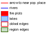

Map legend
Administrative boundaries
Overview map showing large firelocations detected over the last 10 days

Overview
Latest maps maps showing fireactivities of 2 May 2004 (selection)


Kazakhstan Kazakhstan Kazakhstan


Kazakhstan Kazakhstan Kazakhstan
More maps of other regions are available on request: info@gfmc.org
For moredetails on fire in Kazakhstan:
