GFMC: Forest Fires in the Russian Federation
Forest Fires in the Russian Federation
16 May 2003
Latest Satellite Images:


Satellite Terra
14 May 2003, 0325 AM
Pixel size 1km Satellite Aqua
14 May 2003, 0505 AM
Pixel size 500m Satellite Aqua
15 May 2003, 0550 AM
Pixel size 500m
Fires in south eastern Russia
In south eastern Russia (near chinese border), scores of fires are burning. This Moderate Resolution Imaging Spectroradiometer (MODIS) image from the Auqa and Terra satellite shows active fires marked with red dots. The fires are producing rivers of smoke which extend far to the south into China and have spread eastward over the Pacific Ocean.
Source: MODIS
Smoke Over Eastern Russia
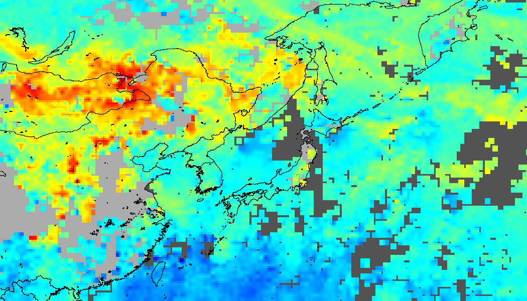
Between May 3-8, 2003, carbon monoxide filled the skies over southern Russia (top), Mongolia (below left), and China (below right). This image shows measurements of carbon monoxide captured by the Measurements of Pollution in the Troposphere (MOPITT) sensor on the Terra satellite, with values ranging from zero (dark blue) to 360 parts per billion (red). The carbon monoxide was coming from hundreds of fires burning in the region at the start of the farming season. Smoke plumes from these fires spread far out over the Pacific Ocean to the east. (Source NASA EO)


20030511 20030512 20030513 20030514
Latest fullday Earth Probe TOMS Aerosol Index map.
(Source: NASA GSFC)
Avialesookhrana from the National Forest Fire Centre of Russia provides up-to-date NOAA images for the whole of the Russian Federation and neighbour territories. The Space Monitoring Information Support Laboratory provides extensive links to sites with satellite imagery for the Russian Federation, meteorological information as well as fire related images are accessible.
The NOAA AVHRR satellite image composite shows fire activities in the Russian Federation.

Latest NOAA 12&14 AVHRR composite
The red squares indicate regions of active fires. For details the GFMC readers are encouraged to use the hyperlinks provided by Avialesookhrana, the Aerial Forest Fire Protection Service of the Federal Forest service of Russia.
(Source: Avialesookhrana cloudiness maps)
Latest fire situation report by the Aerial Forest Fire Protection Service of Russia (Avialesookhrana), 15 May 2003
For the last days fire activities retain still very severe in Chita region. Pretty good fire activities in Amur, Irkutsk, Buriatia, Iakutia, Krasnoiarsk, Altaiy regions. In Europea part of Russia are staying nice , sunny weather so fires have started up to Leningrad and Karelia regions. But it are spring fires yet.
According to the situation report of the Ministry of Natural Resources of 15 May 2003 a total of 618 fires affected 16,352 ha forested and 3,576 ha non-forested areas. 196 fires of them were reported as new fires. In addition 141 fires occurred that were put out the same day when they started.
Since the beginning of the 2003 fire season a total of 8,409 fires affected 391,441 ha forested and 150,362 ha non-forested land under the responsibility of the Ministry of Natural Resources. (For comparison: Last year up to this date 7,928 fires had burnt 118,445 ha forested and 60,496 ha non-forested lands.)
Most fires have been reported in the following regions:
-
Chita region – 161 fires
-
Iakutia-63
-
Buriatia – 69
-
Irkutsk – 140
-
Amur 34
-
Altay-40
-
Krasnoiarsk-45
-
Vologda-27
-
Karelia-10
-
Vladimir-15
-
Tver-14
-
Moscow-7
Large fires were reported in:
-
Amur-3 fires, the biggest is 430 ha.
-
Chita region – 120 fires, the biggest is 9,000 ha. 54 of them-are contained. 11 large fires were put out for last day.
-
Buriatia 18 fires, the biggest is 610 ha.
-
Iakutia-3, the biggest is-2,500 ha.
-
Altay 7 fires, the biggest is 1,000 ha. All of them in contained stage.
-
Irkutsk -8 fires, the biggest is 155 ha.
Through all of Russia 8,034 people, 58 aircraft, 1,418 bulldozers, tractors and engines have been involved in fire fighting.
Source: Aerial Forest Fire Protection Service of Russia (Avialesookhrana)
Eurasian Experimental Fire Weather Information System
The system has been developed by forest fire researchers from Canada, Russia and Germany is displayed on this website starting 18 July 2001. Complete information and a set of daily fire weather and fire behaviour potential maps covering Eurasia (the Baltic Region, Eastern Europe, countries of the Commonwealth of Independent States, Mongolia) can be accessed at:
https://gfmc.online/fwf/eurasia1.htm

Example of the Eurasian Experimental Fire Weather Information System:
Latest map of the Experimental Fire Weather Index (FWI) for Russia and neighbouring countries
Daily Fire Occurrence and Fire Danger Maps of the Fire Laboratory of the Sukachev Institute of Forest, Krasnoyarsk
Selected fire occurrence maps, satellite images and a forest fire danger map are prepared daily by the Russian GFMC correspondent Dr. Anatoly Sukhinin, Fire Laboratory of the Sukachev Institute of Forest, Krasnoyarsk, in collaboration with the Emergency Situation Monitoring and Forecasting Agency, Krasnoyarsk branch. The maps are produced on the base of satellite data (classification by the NOAA AVHRR). They show the fire locations (by latitude and longitude) and the area affected by fire (red signature, size in ha). The red arrow at each fire location points to the nearest populated place. The terms Oblast or Kray used in the maps are designations of administrative regions. A map showing the boundaries of administrative regions and a legend is included below.

Map legend
Administrative boundaries
Overview map showing large fire locations detected over the last 10 days

Overview
Latest maps maps showing fire activities (selection)


Aginskiy Buryatskiy a.o. Altayskiy Kray Altayskiy Kray


Altayskiy Kray Altayskiy Kray Amurskaya Oblast


Buryatiya Republic Buryatiya Republic Buryatiya Republic
For more details on fire in the Russian Federation:
Bibliography on fire in ecosystems of boreal Eurasia:
One of the results of the first international fire science conference in the Russian Federation (1993) was the publication of a monograph on fire in boreal Eurasia, including some selected contributions on boreal North America. The literature cited in the monograph contains numerous publications which in many cases are not easily accessible. To facilitate literature search the bibliographical sources are provided by topic (chapter).
Goldammer, J.G. and V.V.Furyaev. 1996. Fire in Ecosystems of Boreal Eurasia. Kluwer Academic Publishers, Dordrecht, 390 p.
