Guatemala Fire Emergency Assistance Request, 27 June 2001
Fire Activities in Guatemala
09May 2003
New Satellite Images

Fires in Mexico and CentralAmerica
Fires continue to burn all across Mexico and Central America on May 5, 2003.This true-color ModerateResolution Imaging Spectroradiometer (MODIS) image from the Terrasatellite shows active fire locations marked with red dots. Smoke blankets theregion and extends northward over the Gulf of Mexico, southward over the PacificOcean, and eastward over the Caribbean Sea. The high-resolution image providedabove is 500 meters per pixel. The MODIS Rapid Response System provides thisimage at MODIS maximum spatial resolution of 250meters.
Source: NASA/EO

The widespread and intense biomass burning ocurring on the Yucatan Peninsula and other parts of Central America is producing high concentrations of carbon monoxide (CO) in the lower atmosphere, as shown in this image of observations by the Measurements of Pollution in The Troposphere (MOPITT) instrument aboard NASAs Terra satellite. This false-color image shows the mixing ratios of CO at an altitude of about 3 km (700 hPa) averaged from April 25 to May 1, 2003. Gray areas indicate where no data are available.The highest mixing ratios are seen over the Yucatan Peninsula and over the border between Mexico and Guatemala. Carbon monoxide levels as high as 360 parts per billion by volume of air (red pixels) were measured. The orange and yellow pixels indicate high levels of CO over the countries south of GuatemalaHonduras, El Salvador, and Nicaragua. The pollution is also being carried northeastward over the Gulf of Mexico toward the U.S. gulf coast states and the western parts of the Caribbean.Images from the MODIS instruments aboard the Terra and Aqua satellites show the locations of the numerous fires across the region during this same time period as well as the thick, widespread pall of smoke they produced.
Source: NASA/EO

Heat signatures (red) and smoke (light blue haze) are visible from fires burning in parts of Mexico, Guatemala, and Belize inthis MODIS (Moderate Resolution Imaging Spectroradiometer) image from 08 May2003, captured by the Aqua satellite. Smoke (indicated by the yellow arrows) is visible extending over the Gulf of Mexico and Gulf of Honduras.
Source: OSEI
WeatherForecast for Petén (Flores) for the next days:
http://www.wunderground.com/global/stations/78615.html
the nextdays will bring clouds but no major rainfall.
CONREDUpdate
There isno SITREP available from CONRED (Coordinadora Nacional para Reducción deDesastres). For SITREPS of the March 2003 fires see:
http://www.conred.org/eventos/incendios_peten_marzo_2003/index.php#2
GFMCUpdate 4 May 2003
On 25April 2003 the GFMC has alerted UN OCHA/UNEP Environmental Emergency Sectionabout the situation in Guatemala and Nicaragua. OCHA’s Response CoordinationBranch has contacted United Nations Resident Coordinators in Guatemala andNicaragua concerning the possibilities of international technical assistance.Bilateral assistance from Mexico was received, see:
https://gfmc.online/gfmcnew/2003/0428/20030428_gt.html
Latest Media Reports (Prensalibre)
4 May 2003
TheMaya Biosphere Reserve a land without law. Petén: Invadors and drug dealersare operating with impunity in the reserve.The 1.4 million ha reserve has been created in 1990 to protect the natural andcultural resources of the area. However, it has turned out that the area is aland without law. The reserve intended to protect the land against invaders bygiving multiple-use rights to a local community. The reality is illegal fellingand smuggling of timber, sale of archaeological cultural goods and drugsmuggling. Survey flights after the forest fires reveal that numerous illegalforest roads have been constructed for these purposes. Usurpers must be removed.<brief GFMC summary>
Biosfera Maya, tierra sin ley
Petén: Invasores y traficantes de ilegales, drogasy animales operan toda impunidad en la reserva
Por : AlbertoRamírez

Los 378 incendios ocurridos este año en la reserva petenera, actualizaron el desinterés del Gobierno en su conservación, a causa de lo cual florecen en ella el tráfico de drogas e ilegales y la depredación cultural y de fauna, mientras avanza la frontera agrícola.
En 1990 fue creada la Reserva de la Biosfera Maya, RBM, con el objetivo deproteger los recursos naturales y culturales del área, pero en la actualidad seha convertido en una tierra sin ley.
Las amenazas contra la RBM son la ampliación de la frontera agrícola yganadera, cazadores de especies y narcotraficantes, y eventualmente saqueadoresde sitios arqueológicos, señala Carlos Albacete, director de Trópico Verde.
Una herramienta diseñada para proteger el bosque fue la concesión forestal acomunidades dentro de la zona de usos múltiples, donde podrían vivir delmanejo racional del bosque, con la condición de que no habría más invasionesen esas áreas.
Pero la debilidad estatal para monitorear, proteger y sancionar a usurpadores hahecho que en caminos de entre La Colorada, La Pasadita, Cruce La Colorada, SanMiguel la Palotada y Carmelita se observen innumerables agarradas, dondenuevos invasores cortan los árboles y luego los queman para cambiar el uso delsuelo.
Aquí cualquiera puede venir a invadir, tumbar el bosque, quemarlo y traerganado o sembrar milpa, expresó Albacete.
Los comunitarios afirman haber presentado más de 40 denuncias de usurpación alMinisterio Público y el Consejo Nacional de Areas Protegidas, Conap, pero nuncahan investigado.
Los vecinos tienen miedo y muchos han sido desplazados hacia zonas núcleo,donde empiezan a quemar bosque para preparar la tierra, mientras los antiguosterrenos pasan a manos de ganaderos con menor poder económico.
En comunidades como Carmelita, nadie lo acepta, pero comentan sobre la forma enque alguna vez colaboraron en el tráfico de ilegales o la venta de piezasarqueológicas.
Los sobrevuelos efectuados a raíz de los incendios forestales tambiénsirvieron para reconocer los numerosos caminos construidos por el tráficoilegal de madera, especies en peligro de extinción y posiblemente por elnarcotráfico.
El Parque Nacional Laguna del Tigre se ha convertido no sólo en una ruta deilegales sino de narcotraficantes. Al llegar a comunidades como Santa Amelia, leadvierten a los visitantes que no deben transitar por ciertos caminos, por lapresencia de hombres armados.
El personal del Conap hace sus mejores esfuerzos, pero se siente indefenso paraenfrentar a grandes enemigos sin el apoyo del Gobierno.
Nuestro presupuesto es muy bajo para enfrentar esas amenazas, diceMynor Barrios, director de Biotopos de Petén, cuyas reservas están amenazadaspor agricultores y ganaderos.
En cada país hay un problema con sus parques, pero en Guatemala sus parquesenfrentan muchos problemas juntos, dijo Cris Fagan, de Parks Watch, de laUniversidad Duke, Carolina del Norte, Estados Unidos, y quien hace una evaluaciónde la RBM.
La primera acción sería atender las denuncias y sacar a los usurpadores,dice Albacete, quien destaca que de 1.4 millones de hectáreas de la RBM sóloquedan 7,500 de bosque, y en unos cuantos años únicamente existirán losparques nacionales.

Paso Caballos, situado dentro del Parque Laguna del Tigre, es una muestra del proceso de deterioro de la reserva forestal ante los impactos de la presencia humana dentro de la Biosfera Maya. Foto Prensa Libre: ALBERTO RAMIREZ ESPADA.
Source: Prensalibre
Earliersatelliteimages and other information of the fires in March 2003:
SeeGFMC updates between 21 and 25 March and from 18 April to date:
21March 2003:
https://gfmc.online/gfmcnew/2003/0321/20030321_gt.html
22 March 2003:
https://gfmc.online/gfmcnew/2003/0322/20030322_gt.html
23 March 2003:
https://gfmc.online/gfmcnew/2003/0323/20030323_gt.html
24 March 2003:
https://gfmc.online/gfmcnew/2003/0324/20030324_gt.html
25 March 2003
https://gfmc.online/gfmcnew/2003/0325/20030325_gt.html
18 April 2003:
https://gfmc.online/gfmcnew/2003/0418/20030418_gt.html
19 April 2003:
https://gfmc.online/gfmcnew/2003/0419/20030419_gt.html
22 April 2003:
https://gfmc.online/gfmcnew/2003/0422/20030420_gt.html
23 April 2003:
https://gfmc.online/gfmcnew/2003/0422/20030423_gt.html
24 April 2003:
https://gfmc.online/gfmcnew/2003/0424/20030424_gt.html
25 April2003:
https://gfmc.online/gfmcnew/2003/0425/20030425_gt.html
Basic Information about Petén
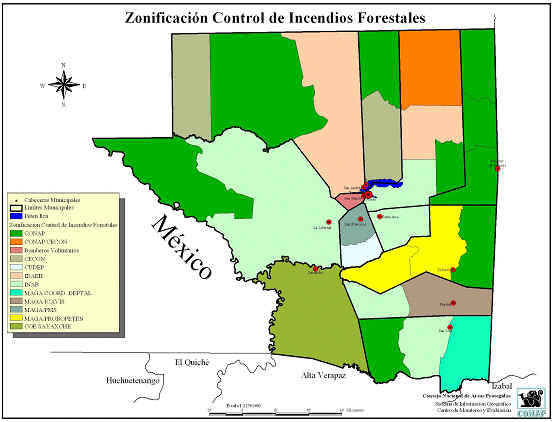
Figure1. Areas of forestfire control responsibility in Petén, Guatemala. Source:
Comisión de Incendios Forestales de Petén.

Figure2. Topographicfeatures of Petén, Guatemala. Source: Comisión de Incendios Forestales de Petén.
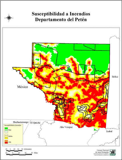
Figure3. Wildland firesusceptibility map of Petén, Guatemala. Legend of susceptibility:
Green = low; yellow = medium; red = high. Source: Comisión de Incendios Forestales de Petén.
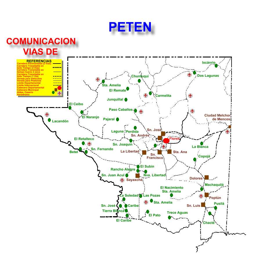
Figure 4. Raod map for Petén. Source: Sistema deInformación para las
Áreas Protegidas de Petén (SI PETEN)
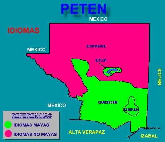
Figure 5. Language map for Petén. Source: Sistema de Información para
las Áreas Protegidas de Petén (SI PETEN)
Health Guidelines for Vegetation Fire Events
Information on protection of people from vegetation fire smokecan be found in the guidelines document. Please enter the document through theGFMC portal at:
https://gfmc.online/programmes/un/who/who.html
Regional Mesoamerica Wildland Fire Network: Regional andnational widland fire status reports
The website of the regional Mesoamerica network contains a largenumber of national and regional analyses on wildland fire, including thesituation in Petén, Guatemala:
https://gfmc.online/GlobalNetworks/MesoAmerica/MesoAmerica.html
Sistema Nacional de Prevención y Control de Incendios Forestales(SIPECIF)
http://www.sipecif.gob.gt/portal.html
