Guatemala Fire Emergency Assistance Request, 27 June 2001
Fire Activities in Guatemala
2May 2003
Latest Satellite Image:

Fires in Mexico and Central America
A thick haze of smoke covers southern Mexico and Central America in thistrue-color ModerateResolution Imaging Spectroradiometer (MODIS) image from the Aquasatellite on April 30, 2003. Although fire is commonly used in agriculture toclear land for planting crops, such fires can easily get out of control and growinto wildfires. In Nicaragua (bottom right corner), forest fires have beenraging for the past three months, and have destroyed crops, tree plantations,and forests. The fires in this image are marked in red. They are spread acrosssouthern Mexico (top), then in Guatemala (south of Mexico), Honduras (to theeast) and El Salvador (to the south), and Nicaragua. Smoke is spreading out overthe Gulf of Mexico (top) and the Caribbean Sea (right).
Source: MODIS

Heat signatures (red) and smoke (light blue haze) are visible from fires burning in parts of Mexico, Guatemala, and Belize in this MODIS (Moderate Resolution Imaging Spectroradiometer) image from the Aqua satellite. Smoke (indicated by the yellow arrows) is visible extending over the Gulf of Mexico and Gulf of Honduras.
Source: OSEI
WeatherForecast for Petén (Flores) for the next days:
http://www.wunderground.com/global/stations/78615.html
the nextdays will bring clouds but no major rainfall.
Important Note: SinceThursday 1 May 2003 there is no update information available on the situation inGuatemala and Nicaragua.
CONREDUpdate
There isno SITREP available from CONRED (Coordinadora Nacional para Reducción deDesastres). For SITREPS of the March 2003 fires see:
http://www.conred.org/eventos/incendios_peten_marzo_2003/index.php#2
GFMCUpdate 1 May 2003
On 25April 2003 the GFMC has alerted UN OCHA/UNEP Environmental Emergency Sectionabout the situation in Guatemala and Nicaragua. OCHA’s Response CoordinationBranch has contacted United Nations Resident Coordinators in Guatemala andNicaragua concerning the possibilities of international technical assistance.Bilateral assistance from Mexico was received, see:
https://gfmc.online/gfmcnew/2003/0428/20030428_gt.html
Latest Media Reports (Prensalibre)
1 May 2003
Forest Fires Under Control. Out of the47 forest fires burning in Petén last week only three fires continue to burn.Eight hours of rains helped to extinguish. Low pressure and more rains will easethe situation <GFMC short summary>
Incendios forestales bajo control
Por : Crista Kepfer
De 47 incendios que afectaron a Petén la semana pasada,ayer sólo quedaban activos tres, los cuales están bajo control.
Así lo indicóArturo Lemus, coordinador del Sistema Nacional de Prevención de IncendiosForestales, Sipecif.
Ayer lloviódurante ocho horas, y esto ayudó a detener los incendios en un 70 por ciento enel norte de Petén, dijo en conferencia de prensa Carlos Cáceres, ministrode Ambiente y Recursos Naturales.
Pese a que aúnno ha llegado el invierno, ayer por la madrugada cayeron fuertes aguaceros.
El Institutode Sismología, Vulcanología, Meteorología e Hidrología informó que se debena sistemas de baja presión, y que se prevén más lluvias para los próximos días.
Source:Prensa Libre
http://www.prensalibre.com/pls/prensa/detnoticia.jsp?p_cnoticia=55114&p_fedicion=01-05-03
Earliersatelliteimages and other information of the fires in March 2003:
SeeGFMC updates between 21 and 25 March and from 18 April to date:
21March 2003:
https://gfmc.online/gfmcnew/2003/0321/20030321_gt.html
22 March 2003:
https://gfmc.online/gfmcnew/2003/0322/20030322_gt.html
23 March 2003:
https://gfmc.online/gfmcnew/2003/0323/20030323_gt.html
24 March 2003:
https://gfmc.online/gfmcnew/2003/0324/20030324_gt.html
25 March 2003
https://gfmc.online/gfmcnew/2003/0325/20030325_gt.html
18 April 2003:
https://gfmc.online/gfmcnew/2003/0418/20030418_gt.html
19 April 2003:
https://gfmc.online/gfmcnew/2003/0419/20030419_gt.htm
22 April 2003:
https://gfmc.online/gfmcnew/2003/0422/20030420_gt.htm
23 April 2003:
https://gfmc.online/gfmcnew/2003/0422/20030423_gt.htm
24 April 2003:
https://gfmc.online/gfmcnew/2003/0424/20030424_gt.html
25 April2003:
https://gfmc.online/gfmcnew/2003/0425/20030425_gt.html
Basic Information about Petén
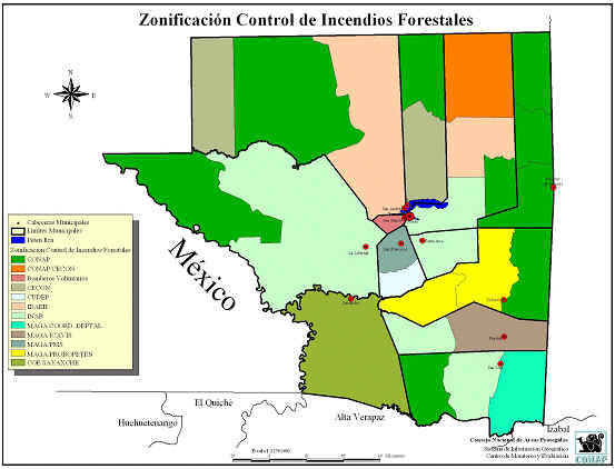
Figure1. Areas of forestfire control responsibility in Petén, Guatemala. Source:
Comisión de Incendios Forestales de Petén.

Figure2. Topographicfeatures of Petén, Guatemala. Source: Comisión de Incendios Forestales de Petén.
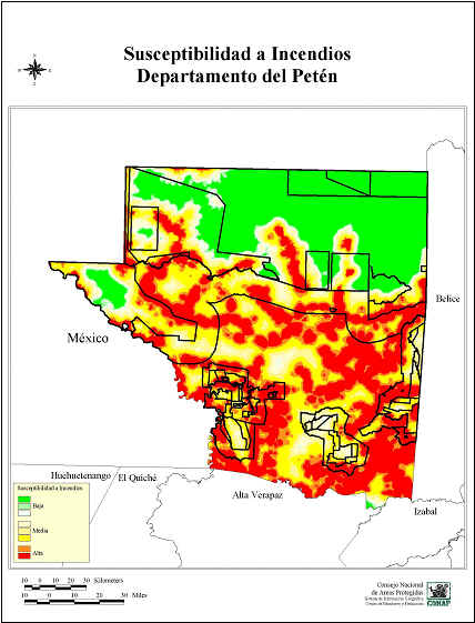
Figure3. Wildland firesusceptibility map of Petén, Guatemala. Legend of susceptibility:
Green = low; yellow = medium; red = high. Source: Comisión de Incendios Forestales de Petén.
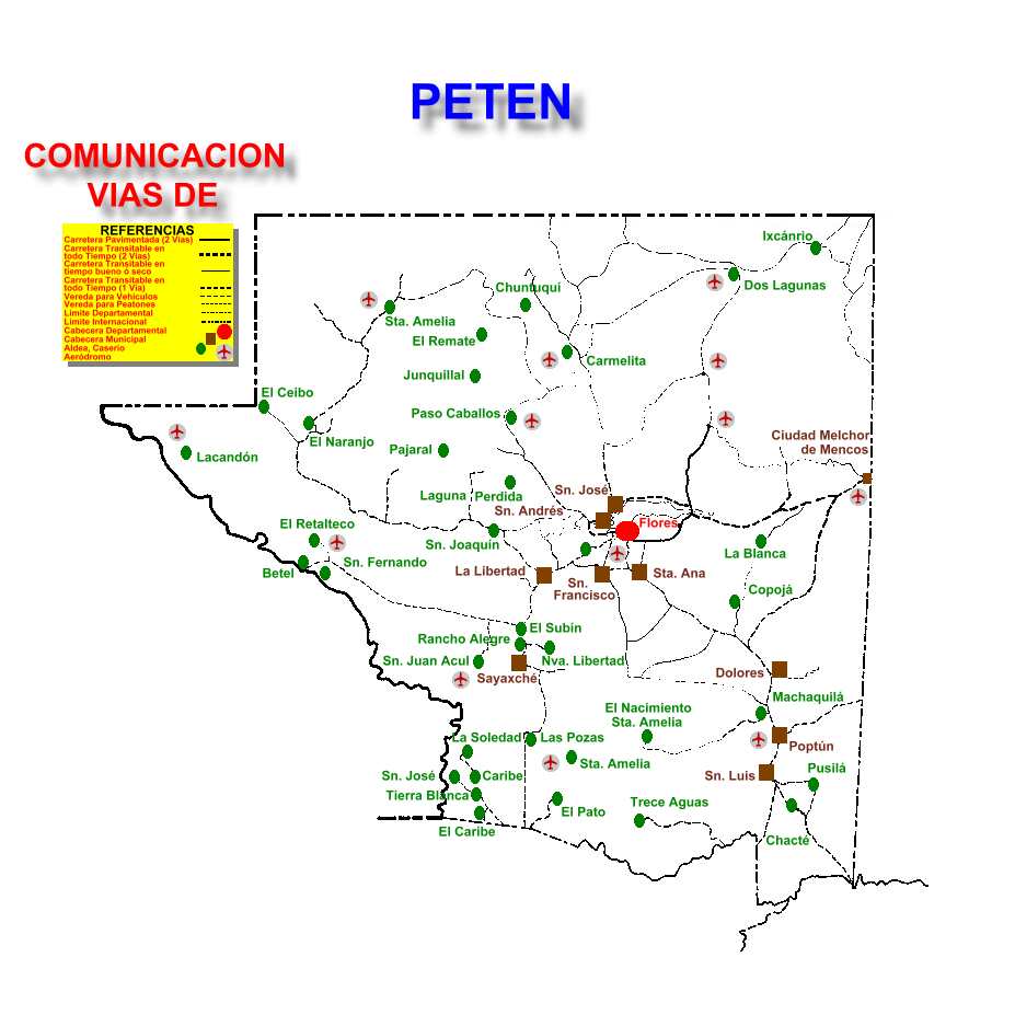
Figure 4. Raod map for Petén. Source: Sistema deInformación para las
Áreas Protegidas de Petén (SI PETEN)
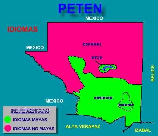
Figure 5. Language map for Petén. Source: Sistema de Información para
las Áreas Protegidas de Petén (SI PETEN)
Health Guidelines for Vegetation Fire Events
Information on protection of people from vegetation fire smokecan be found in the guidelines document. Please enter the document through theGFMC portal at:
https://gfmc.online/programmes/un/who/who.html
Regional Mesoamerica Wildland Fire Network: Regional andnational widland fire status reports
The website of the regional Mesoamerica network contains a largenumber of national and regional analyses on wildland fire, including thesituation in Petén, Guatemala:
https://gfmc.online/GlobalNetworks/MesoAmerica/MesoAmerica.html
Sistema Nacional de Prevención y Control de Incendios Forestales(SIPECIF)
http://www.sipecif.gob.gt/portal.html
