GFMC: Forest Fires in the United States
Forest Fires in the United States
25 August 2003
Latest Satellite Images:
Fires in Oregon
Heat signatures and smoke plumes (light blue haze) are visible from several fires burning in Oregon. The B & B Complex Fire has scorched 10,900 acres in Deschutes National Forest. This information is from the National Interagency Fire Center’s Incident Management Situation Report from22 August 2003.
Source: OSEI
Fires in Oregon
The fire complex known as the B&B Fire to firefighters is composed of theBooth (south) and Bear Butte (north) Fires in Oregon. As of Sunday night (24August 2003), the fire was affecting more than 36,000 acres and was 20 percentcontained. This image shows the actively burning areas of the fires detected bythe Moderate ResolutionImaging Spectroradiometer (MODIS) on the Aquasatellite marked with yellow. The image was acquired on 24 August 2003. The graypatch at upper left is the city of Portland.
Source: NASA/ EO
Rain helps firefighters in Montana
HELENA, Mont. (AP) Rain fell over much of western Montana Saturday, clearing the sky of smoke and bringing relief to thousands of firefighters trying to control blazes that have blackened more than 400,000 acres.”It’s going to give the fire crews a breather,” said Susan Rinehart, information officer for the Northern Rockies Coordination Group. “You still have very serious dry fuels out there.”Some parts of western Montana received more than half an inch of rain from late Friday into early Saturday, the state’s first significant rainfall in a month.In the Missoula area, which is virtually surrounded by fires, the rain helped clear smoke that had been sending people to hospitals.The Forest Service said it has spent more than $100 million fighting dozens of fires in Montana this summer. A number of blazes in eastern and central Montana have been contained, including a 38,000-acre fire near Billings.Crews in Oregon took advantage of cool, damp weather Saturday to fortify defenses for the resort town of Camp Sherman and Black Butte Ranch, a nearby golf resort community, before the return of dry weather.The 300 or so residents of Camp Sherman were evacuated on Thursday but were told they could return for three hours Sunday to collect essentials that may have been left behind.Camp Sherman is about four miles from a group of fires that had charred 24,000 acre in three days in the Deschutes National Forest of central Oregon. The blaze had destroyed eight cabins and an auditorium at a campground near Round Lake, along with outbuildings near the Hoodoo Ski Area.In western Wyoming, crews aided by water-dropping helicopters made headway Saturday against a 14,500-acre blaze in Shoshone National Forest, about 25 miles southwest of Cody. Crews worked to keep the fire away from several homes and dude ranches on the south fork of the Shoshone River, but no evacuations were ordered.Officials in northwestern Wyoming hoped to complete firebreaks ahead of two blazes to keep them from leaving Yellowstone National Park and threatening private property.The fires, which together had burned 20,500 acres in eastern Yellowstone, were 25% contained, information officer Greg Thayer said.Yellowstone officials said the park’s east entrance, which had been closed for about a week and a half because of fire, would reopen on a limited basis Sunday. The road will be open for three hours in the morning and three in the evening for the foreseeable future, fire information officer Peter Frenzen said.Copyright 2003 The Associated Press. All rights reserved. This material may not be published, broadcast, rewritten or redistributed.
Source: USTODAY
The National Interagency Fire Center (NIFC) based in Boise (Idaho) provides key information on current wildland fire situations, related information and background materials. The following information is updated daily and can be accessed directly:
-
State-by-State daily and year-to-date summary of fire activities
http://www.nifc.gov/fireinfo/nfn.html
-
Year-to-date State-by-State total number of wildland fires and area burned (table)
http://www.nifc.gov/fireinfo/nfnmap.html
-
Daily locations of large fires (map)
http://www.nifc.gov/fireinfo/firemap.html
The National Interagency Coordination Center (NICC) provides daily situation reports. These reports include:
-
Incident Management Situation Reports (fires and area burned reported to NICC). The files include current, previous and archived reports
-
Prescribed Fire and Wildland Fire Use (year-to-date fires and area burned reported to NICC, posted weekly on Monday mornings)
http://www.nifc.gov/news/RXWFUYTD.htm
Archived NICC Incident Management Reports (recent daily reports and archived daily reports 1994-1997) are provided by the Center for International Disaster Information (CIDI)
More current Information about the fire situation inUnited States from 25 August, See: The National Incident Management Situation Report by NICC
The National Wildfire Information Interagency provides detailed information on each individual state with active fires.
Fire Weather & Fire Danger Information
The Wildland Fire Assessment System (WFAS) is a contribution of “The Fire Behavior Research Work Unit”, Missoula (Montana USA). The broad area component of the Wildland Fire Assessment System (WFAS) generates maps of selected fire weather and fire danger components.
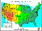
Fire Danger (Potential) is a normalized adjective rating class across different fuel models and station locations. It is based on information provided by local station managers about the primary fuel model, fire danger index selected to reflect staffing level, and climatological class breakpoints. Low danger (Class 1) is green and extreme potential (Class 5) is red.
fire danger (observed time) fire danger (forecasted)
Latest fire dangermap for the United States (observation time) and forecasted fire danger map forthe subsquent day
(Source: WAFS)
Dead fuel moisture responds solely to ambient environmental conditions and is critical in determining fire potential. Dead fuel moistures are classed by timelag.
10-HR Fuel Moisture 100-HR Fuel Moisture 1000-HR Fuel Moisture
Latest fuel moisture maps for conterminousUS
(Source: WAFS)
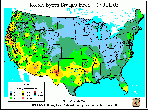
The Keetch-Byram Drought Index (KBDI) is a soil/duffdrought index. Factors in the index are maximum daily temperature, dailyprecipitation, antecedent precipitation, and annual precipitation. The indexranges from 0 (no drought) to 800 (extreme drought) (details).
Latest Keetch-Byram drought index map for conterminousUS
(Source: WAFS)
For more Satellite Images displaying recent fires in the US, please visit NASA´SEarth Observatory at:
http://earthobservatory.nasa.gov/NaturalHazards/natural_hazards_v2.php3?topic=fire. EarthObservatory provides MODIS and Landsat Scenes of fires allover the planet.
For more information on the recent fire situation in the US see also: Recent Media Highlights on Fire, Policies, and Politics.
Long-range weather forecasts
National Weather Service
Long-range, 30-day weather forecasts are predicting above-normal temperatures for the southern tier of states from southern California to Florida and throughout the Midwest (see 30 and 90-day forecast maps).
30 and 90-day temperature and precipitation forecast maps(August to October 2003)
(Source: National Weather Service)
For further information see: Wildfire Season Forecast of the Florida Division of Forestry
For further information you may also see to the U.S. Drought Monitor.
For background information on the Southern Area see the Edited Version of the Southern Area Intelligence Briefing Paper for 22 April 2001.


