ECPC/NCEP Global to Regional Weather Forecasts
Global to Regional Fire Weather Forecasts
(IFFN No. 17 – July 1997; updated 17 June 1999)
Weather forecasts at short to extended time ranges and global to regional space scales could be more effectively utilized for wildland fire management. An experimental modeling system, developed at NCEP for making short-range global to regional weather forecasts, is currently being used to make and disseminate experimental global to regional, fire weather forecasts focused on Southern California. This fire weather forecasting system could be easily transported anywhere else in the world. A description of current and planned products is provided below.
Background
Improved fire weather forecasts are needed at a variety of time and space scales. At large space and time scales, accurate fire weather forecasts have potential for the long range planning of allocation of scarce resources. At smaller time and space scales accurate fire weather forecasts have potential use in alerting, staging and planning the deployment of fire crews and equipment. At the smallest time and space scales, accurate fire weather forecasts can be helpful in fighting fires as well as determining optimal periods for setting prescribed silvicultural fires (Fosberg and Fujioka 1987).
Current U.S. fire weather forecasts are prepared from short-range weather forecasts (1-2 days) by the National Center’s for Environmental Prediction (NCEP’s) Eta model, model output statistics, and human judgment. These fire weather forecasts include information about precipitation, wind, humidity, and temperature. At weekly to monthly time scales, only forecasts for mean precipitation and surface temperature are available from the Climate Prediction Center at NCEP (see Epstein 1988, Wagner 1989). Basically, NCEP’s global medium range forecast (MRF) model forecasts are combined with persistent, statistical, and human forecasts to make an extended forecast of the 700 mb height. “Perfect Prog” statistical models developed by Klein (1985) and Klein and Bloom (1987), which assume the 700 mb as perfectly prognosticated, are then used to predict surface temperature and precipitation. Klein and Whistler (1991) further extended these kinds of forecasts by finding statistical relationships between the monthly averaged 700 mb height and monthly mean temperature, dewpoint, wind speed, and precipitation frequency.
Global to Regional Fire Weather Forecasts
Juang and Kanamitsu’s (1994) experimental modelling system, developed at NCEP for making short-range global to regional weather forecasts, is being used to make longer-range experimental global to regional, fire weather forecasts. At the largest space and time scales, the modeling system uses NCEP’s MRF or GSM (global spectral model). A high resolution regional spectral model (RSM), is nested within the global model by first integrating the GSM, which provides initial and low spatial resolution model parameters as well as lateral boundary conditions for the RSM. The RSM then predicts regional variations influenced more by the higher resolution orography and other land distributions within a limited but high resolution domain. Both models use the same 28 terrain following sigma layers, the same comprehensive set of physical parameterization modular packages, and the same diagnostic packages, which include land surface parametres (e.g. soil wetness, soil temperature, etc.), sensible and latent heat fluxes, radiation fluxes, cloudiness, various three dimensional heating and moisture distributions, and max/min temperatures, etc. (Kalnay et al. 1996). Global to regional forecasts of the fire weather index (Appendix) and precipitation are currently displayed on our Experimental Climate Prediction Center’s world-wide web site for several regions (Global, Pacific Ocean, Conterminous U.S., U.S. South West, California/Nevada, Africa, Middle East, Western Pacific, South America, Europe) and several forecast times up to 168 hours after the initial date. The entire globe is shown at 100 km resolution; the entire U.S. is shown at 50 km resolution; California is shown at 25 km resolution. Separate forecasts are displayed as entries in a table (the original Fig.1 of the printed version of IFFN is not included here because the tables have undergone significant changes; instead, a more recent example of the global FWI prediction is displayed in Fig.1). Each row of each table is a separate forecast and the initial date and initial hour are indicated in the leftmost column; validation times are indicated by the column headings. As shown in Figures 2 and 3, these times are repeated as the title of each individual forecast. All times are in UTC times; local time depends upon location. Also available are combinations of all the latest forecasts in a self-animated GIF files, which effectively summarize daily activities of each forecast. Note that a high fire weather index is represented by dark colours. For California (Fig.3), the speed and direction of the surface (10 meter) wind is also indicated, as is the surface elevation.

Fig.1. Screenshot of a global fire weather forecast product table (17 June 1999). The tables which allow the selection of daily updated products are available at http://ecpc.ucsd.edu/m2s/m2s_ECPC_forecasts.html. Individual tables correspond to individual regions, including the globe, U.S., California, Southern California, Hawaii. Each row of each table is a separate forecast and the initial date and initial hour are indicated in the leftmost column. Validation times are indicated by the column headings. Validation times are appended with a v; initial times are appended with an i; forecast times are appended with an f. Opening up each frame provides the forecast. Animated GIF image movies for the latest forecast are available at the bottom of each table.
These forecasts are made in a variety of places. For example, NCEP makes global, U.S., Pacific and Africa forecasts. We transfer a small number of products from these forecasts to provide the FWI and precipitation at our site. Due to bandwidth limitations of the Internet, only the complete initial and 72-hour forecasts 4 times daily (00, 06, 12, 18 UTC) for the global model are transferred. From these global initial and boundary conditions, regional forecasts at 25 km resolution, focused on the California-Nevada region, are then made and also displayed. We chose to initialize and force the RSM from the NCEP global forecast instead of initializing the RSM from the 50 km RSM forecasts, in order to retain the ability to forecast anywhere in the globe. In the future, only the global initial conditions will be transferred as we will soon be making global to regional forecasts at longer time periods than are available from NCEP.

Fig.2. Example of a 84-hour global fire weather forecast initialized 00 UTC (ZULU Time = Greenwich Time), 15 June 1999 and valid at 12 UTC, 18 June 1997. The location of solar noon is marked by the sun at 0° longitude. The fire weather index scale is on the right.
Future Work
New features are under development. Besides beginning development of longer-range monthly global to regional forecasts, we are also beginning extensive validation of our fire weather forecasting methodology using recently developed monthly diurnal climatologies, which will be used to assess the accuracy of anomaly forecasts. We are experimenting with the transportability of our global to regional modeling system by making experimental forecasts for Central America, Africa, and Taiwan. At smaller scales, an experimental non-hydrostatic mesoscale model at 2 km resolution, that is an integral part of the global to regional forecast system, is under development. Provision of additional output of corresponding land surface variables such as snow, soil and vegetation moisture are now being extracted and may soon be provided as part of the forecasts; these additional variables are needed to transform fire weather indices into fire danger indices, which include vegetation stresses.
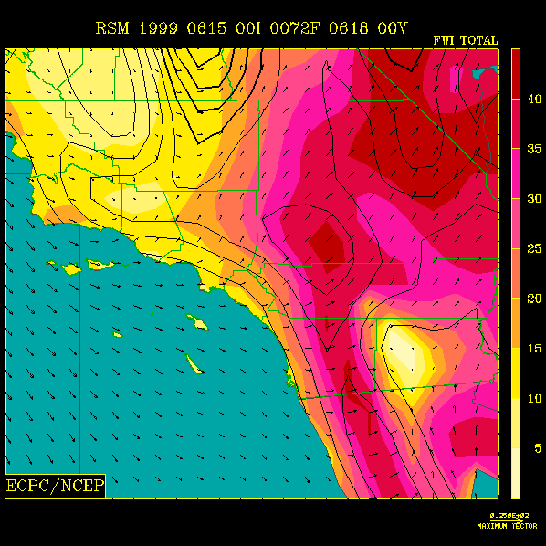
Fig.3. 72-hour Southern California fireweather forecast initialized 00 UTC 15 June 1999 and valid at 00 UTC, 18 June 1999. The fire weather index scale is on the right. The 10 meter surface wind speed and direction are indicated by the arrows. Topography is shown by the contour lines every 250 m.
Appendix: Fire Weather Index
The physical aspects of wildland fire can be quantified in a variety of ways, e.g. rate of spread, rate of thermal energy production, fireline intensity, etc. Similarly, fire danger can be described by a variety of measures. In the United States, the most common measures are those of the U.S. National Fire Danger Rating System (NFDRS; Deeming et al. 1977). By assuming constant fuel (vegetation) characteristics, Fosberg (1978; see also Fujioka and Tsou 1985) derived a simpler fire weather index (FWI) based upon equilibrium moisture content (a function of virtual temperature and relative humidity) and wind speed. Haines et al. (1983) later showed that the FWI was highly correlated with fire occurrence in the U.S. Northeast. Anecdotal evidence suggests that the FWI is a good indicator of fire activity in the U.S. Southwest; for example, major fires of the past decade have been associated with anomalously high occurrences of FWI. The FWI is calculated from:
FWI=(1+W2)1/2(1-2a+1.5a2-.5a3)/.3002, where
a = m/30 m = 0.03229+0.281073R -0.000578RT R<10% m = 2.22749+0.160107R -0.014784T 10%<R<50% m = 21.0606+0.005565R2 -0.00035RT-0.483199R 50%<R.
a is the ratio of equilibrium moisture content to a moisture of extinction of 30. The second quantity in parentheses is called the moisture damping coefficient. The normalized equilibrium moisture content, a, is determined from dry-bulb temperature, T (degrees Fahrenheit), relative humidity, R (percent). W is the wind speed (statute mph). Roads et al. (1991) showed that the temperature dependence of the FWI was almost negligible. For increased temperature, the FWI increases only slightly. Much stronger variations in the FWI occur due to relative humidity and wind speed variations. As might be expected the FWI increases strongly for increased wind speed and decreased relative humidity. Basically, times of potential fire danger (as described by the above simplified FWI) are during windy, relatively dry, and to a lesser extent, warm conditions. The needed meteorological data for the FWI come from NCEP’s GSM/RSM experimental forecasts of 10 m winds and 2 m T and RH, which are assumed to be similar to observed values. Incorporating characteristics of the fuel (vegetation) are needed to further develop this index into a true fire danger index.
John O. Roads and S.-C. Chen
Experimental Climate Prediction Center
UCSD, 0224
U.S.A. – La Jolla, CA 92093
Francis M. Fujioka
USDA Forest Service
U.S.A. – Riverside, CA 92507
H. Juang and M. Kanamitsu
Climate Prediction Center, W/NP51, Rm 604
National Centers for Environmental Prediction
5200 Auth Road
U.S.A. – Camp Springs, MD 20233
References
Deeming, J.E., R.E. Burgan, and J.D. Cohen. 1977. The national fire danger rating system–1978. USDA Forest Service General Technical Report INT-39, 63 pp.
Epstein, E.S. 1988. Long range weather prediction: Limits of predictability and beyond. Weather and Forecasting 3, 69-73.
Fosberg, M.A. 1978. Weather in wildland fire management: the fire weather index. Proc. of the Conference on Sierra Nevada Meteorology, South Lake Tahoe, 1-4.
Fosberg, M.A., and F.M. Fujioka. 1987. Medium- and extended-range fire severity forecasting: A national research plan. Preprints of the Ninth Conference on Fire and Forest Meteorology, San Diego, American Meteorological Society, 273-277.
Fujioka, F.M., and T.-H.Tsou. 1985. Probability modeling of a weather index. Preprints of the Eighth Conference on Fire and Forest Meteorology, Detroit, Society of American Foresters, 239-243.
Haines, D.A., W.A. Main, J.S. Frost, and A.J. Simard. 1983. Fire-danger rating and wildfire occurrence in the northeastern United States. Forest Science 66, 159-164.
Juang, H.-M.H., and M. Kanamitsu. 1994. The NMC nested regional spectral model. Monthly Weather Review 122, 3-26.
Kalnay, E., M. Kanamitsu, R. Kistler, W. Collins, D. Deaven, J. Derber, L. Gandin, S. Saha, G. White, J. Woolen, Y. Zhu, M. Chelliah, W. Ebisuzaki, W. Higgins, J. Janowiak, K. C. Mo, C. Ropelewski, J. Wang, A. Leetmaa, R. Reynolds, and R. Jenne. 1996. The NMC/NCAR Reanalysis project. Bull. Amer. Met. Soc. 77, 437-471.
Klein, W.H. 1985. Space and time variations in specifying monthly mean surface virtual temperature from the 700 mb height field. Monthly Weather Review 113, 277-290.
Klein, W.H., and H.J. Bloom. 1987. Specification of monthly precipitation over the United States from the surrounding 700 mb height field. Monthly Weather Review 115, 2118-2132.
Klein, W.H., and B.T. Whistler. 1991. Specification of monthly mean anomalies of fire weather elements in the United States. Agricultural and Forest Meteorology 56, 145-172.
Roads, J.O., K. Ueyoshi, S.-C. Chen, J. Alpert, and F. Fujioka. 1991. Medium-Range Fire Weather Forecasts, Journal of Wildland Fire 1, 159-176.
Wagner, A.J. 1989. Medium- and Long-Range Forecasting. Weather and Forecasting 4 , 413-426.
