The Wildland Fire Assessment System (WFAS) is a contribution of "The Fire Behavior Research Work Unit", Missoula (Montana USA). The broad area component of the Wildland Fire Assessment System (WFAS) generates maps of selected fire weather and fire danger components.
Fire Danger (Potential) is a normalized adjective rating class across different fuel models and station locations. It is based on information provided by local station managers about the primary fuel model, fire danger index selected to reflect staffing level, and climatological class breakpoints. Low danger (class 1) is green and extreme potential (class 5) is red.
 |
 |
Fire danger maps for the United States for 23
September 2000 (observation time) and 24 September 2000 (forecast)
(Source: Fire Behavior Research
Work Unit, Missoula)
Dead fuel moisture responds solely to ambient
environmental conditions and is critical in determining fire potential. Dead fuel
moistures are classed by timelag. A fuel's timelag is proportional to its diameter and is
loosely defined as the time it takes a fuel particle to reach 2/3's of its way to
equilibrium with its local environment. Dead fuels in NFDRS have four timelag classes:
1-hr: Fine flashy fuels, less than 1/4" (< 0.63 cm) diameter. Responds quickly to
weather changes. Computed from observation time temperature, humidity and cloudiness.
10-hr: 1/4 to 1" (0.63 to 2.54 cm) diameters. Computed from observation time
temperature, humidty, and cloudiness, or may be a standard set of "10-Hr Fuel
Sticks" that are weighed as part of the fire weather observation.
100-hr: 1 to 3" (2.54 to 7.62 cm) diameter. Computed from 24 hour average boundary
condition composed of day length, hours of rain, and daily temperature/humidity ranges.
1000-hr: 3 to 6" (7.62 to 15.24 cm) diameter. Computed from a 7-day average boundary
condition composed of day length, hours of rain, and daily temperature/humidity ranges.
|
|
|
10-HR Fuel Moisture |
100-HR Fuel Moisture |
1000-HR Fuel Moisture |


Fuel moisture maps for conterminous US, 23 September 2000
(Source: Fire Behavior Research
Work Unit, Missoula)
The Keetch-Byram Drought Index (KBDI) is a soil/duff
drought index that ranges from 0 (no drought) to 800 (extreme drought) and is based on a
soil capacity of 8 inches of water. Factors in the index are maximum daily temperature,
daily precipitation, antecedent precipitation, and annual precipitation. KBDI = 0 - 200:
Soil moisture and large class fuel moistures are high and do not contribute much to fire
intensity. Typical of spring dormant season following winter precipitation. KBDI = 200 -
400: Typical of late spring, early growing season. Lower litter and duff layers are drying
and beginning to contribute to fire intensity. KBDI = 400 - 600: Typical of late summer,
early fall. Lower litter and duff layers actively contribute to fire intensity and will
burn actively. KBDI = 600 - 800: Often associated with more severe drought with increased
wildfire occurrence. Intense, deep burning fires with significant downwind spotting can be
expected. Live fuels can also be expected to burn actively at these levels.
For further information on the Keetch-Byram Drought Index (KBDI) by Florida's Division of Forestry /
Forest Protection Bureau please refer to Keetch-Byram Drought Index
Revisited: Prescribed Fire Applications.

Keetch-Byram Drought Index Maps for conterminous US, 23 September 2000
(Source: Fire Behavior Research
Work Unit, Missoula)
The BLM - Alaska Fire Service Initial Attack Management System (IAMS) is suite of computer applications developed by BLM/Fire to aid dispatchers and fire managers. IAMS Maps is one of these applications and provides graphical representation of various kinds of geographic data. Maps has been modified to produce output to a Web site to allow internet access to the data that IAMS stores. Dynamic data such as lightning (available May - September), fires, etc. are updated at the homepage of the BLM - Alaska Fire Service (select Maps / AFS IAMS Maps Viewer) every 15 minutes during the fire season.

IAMS image of active fires in Alaska, 24 September 2000
(Source: BLM - Alaska Fire Service)
GeoMAC Wildland Fire Support
The GeoMAC (Geospatial Multi-Agency Coordination Group) team has produced an
internet based mapping application which allows firefighting coordination centers and
incident command teams to access online maps of current fire locations and perimeters.
Fire perimeter data is updated daily based upon input from incident intelligence sources,
GPS data, IR imagery from fixed wing and satellite platforms. The fire maps also have
relational databases in which the user can display information on individual fires such as
name of the fire, current acreage and other fire status information. Additional data
layers including fuel types, aircraft hazard maps, links to remote weather station data
and other critical fire analysis information are currently being added to the GeoMAC
application.
 |
 |
An example of GeoMAC Wildfire Information on forest fires
in Idaho and Montana.
The right image shows a screen shot about the fire size at the Clear Creek Complex, the
biggest wildfire in Idaho.
(Source: GeoMAC)
Additional Information to the Clear Creek Complex (18 September
2000)
The Clear Creek Complex, 12 miles west of
Salmon, is the largest fire in Idaho, and has an area
206,379 acres. It is to 85% contained. The estimated date of full containment on the Clear
Creek Fire is aprrox. 30 September 2000. Currently, 1585 people, 14 helicopters, 18
engines, 7 dozers are assigned to the fire. Fire behavior on the Clear Creek fire was
minimal Sunday due to the cooler temperatures and higher humidity than Saturday.
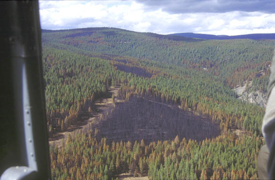 |
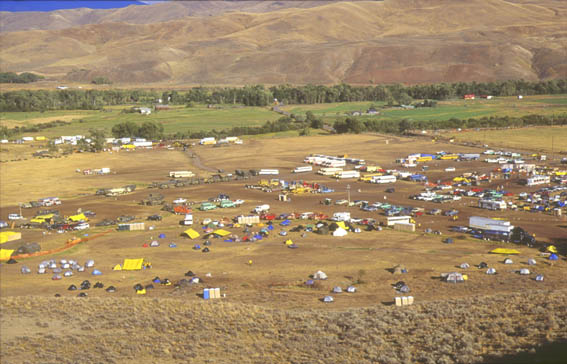 |
A view from the helicopter over parts of the burned area
from the Clear Creek Complex.
The fire base camp two weeks ago.
(Source: GFMC)
Fire and
Aviation Management Morning Report (23 September 2000) [conversion table]
National Overview:
Preparedness Level III
Three new large fires were reported, two in the Southern Area and one in the Eastern Great
Basin. Containment was reached on ten large fires; one in Southern California, one in the
Northern Rockies and eight in the Southern Area. Initial attack activity was light in all
areas. Very high to extreme fire indices were reported in Arizona, Arkansas, California,
Nevada, Oklahoma and Texas.
Summary of Fire Activity Across The United States [conversion table]:
| Yesterday | Year to Date | Ten Year Average | |
| Fires | 148 | 79,590 | 66,120 |
| Acres Burned | 2,138 | 6,841,421 | 3,118,669 |
| Estimated Daily Cost | $3.0 million |
Burned Area Emergency Rehabilitation
Over 4,000 acres of mulching
Over 14,000 acres of invasive weed treatments.
Over 500 miles of road drainage protection.
Over 11,000 acres of intensive erosion barriers being constructed by hand crews on burned
hillsides above high value property.
Over 80,000 acres being seeded to native and annual cereal grasses.
| 65 Rehab Plans | 230,544 acres severely burned | Cost $27 million |

(Source: Salmon-Challis National Forest)
Regional Summary [conversion table]:
- The Southern area remains relatively quiet with good progress being made on the fires. State, F&WS and BIA lands are affected. Some evacuations have taken place in parts of Texas. Over one half of the major fires were contained yesterday.
- In the Rocky Mountain, Northern Rocky Mountains, Eastern Great Basin, and Southwest areas, continued progress is being made with a reduction to 7 fires over 1,000 acres.
Note: Access summary information for individual fires from the NIFC Incident Management Situation Report.
Resources and Statistics:
Resources committed on 23 September 2000:
72 – 20 person crews, 33 helicopters, 1 Battalion military (500 each), 112 engines,
10 air tankers, and 3,060 total personnel. Currently, there are 14 fires over 1,000 acres.
The total number of acres burned this year is 220% of the ten-year average. The Southern
area activity has calmed down with higher humidity and some precipitation. There are still
6 fires over 1,000 acres. Three fires were contained (work necessary to stop the spread of
the fire has been completed) yesterday.
Other Information:
The 3rd Battalion, 2nd Marine Regiment is assigned to the Clear Creek fire in
Idaho.
Weather Outlook (24 September 2000) [conversion table]:
A FIRE WEATHER WATCH IS POSTED FOR MISSISSIPPI FOR LOW FUEL
MOISTURE
Across Oklahoma, Texas and the Gulf Coast states a low pressure will enter the
region helping to spread a cold front across Texas and Oklahoma. This will bring scattered
rain and thunderstorms to the region. High pressure will continue over the Gulf of Mexico.
Ahead of the front, temperatures will warm into the 90's with afternoon humidities ranging
30 to 40 percent inland and 50 to 60 percent along the coastal region. High temperatures
will be in the 60's and 70's behind the front with humidities ranging from 40 to 50
percent. Winds will be from the south at 10 to 20 mph ahead of the front and from the
north after the frontal passage. Across the West Coast high pressure continues to build
over the region as a low pressure moves into the central Rockies by the afternoon. This
continues the warming trend across all areas along with mostly sunny skies west of the
Rockies. Unsettled conditions can be expected across the central Rocky Mountain region.
High temperatures will range from the 40's to 60's in the northern and central Rockies,
the mid 50's to 70's in the remainder of the Northwest and Great Basin and 70's through
the 90's from southwest Oregon into California and the Southwest states. Afternoon minimum
humidities will range from 15 to 30 percent in the driest areas along the west coast and
in the southwest. Winds will be northerly at 10 to 15 mph along the west coast and
northern Rockies, and southwest to west at 10 to 20 mph in the Southwest states.
National
Interagency Fire Center (NIFC)
NIFC Wildland Fire Update
(24 September 2000) [conversion table]
Cooler temperatures and scattered rain showers expected in Texas and Oklahoma today. A
high pressure system will move over the central Rockies today, causing a warming trend
across the west of the Rockies. Firefighters made significant progress on large fires in
Oklahoma and contained six fires yesterday. To date this year, 79,687 fires have burned
6,862,608 acres. The ten-year averages for September 24 are 66,120 fires burning 3,118,669
acres. There are 16 fires are currently burning in California, Idaho, Montana, Nebraska,
New Mexico, Oklahoma, Texas, and Wyoming.
 |
 |
Large Wildland Fires and Large Fire Activity in the
United States, 20 and 24 September 2000.
(Source: NIFC and
US Forest Service)
NIFC Year-to-Date Statistics for the United States (24 September 2000) [conversion table]
| As of 24 September 2000 |
Number of Wildland Fires | Area burnt Acres |
| ten year average | 66,120 | 3,118,669 |
| 2000 | 79,687 | 6,862,608 |
| 1999 | 74,281 | 4,747,036 |
| 1998 | 67,143 | 2,176,795 |
| 1997 | 54,281 | 2,755,791 |
| 1996 | 90,416 | 5,939,702 |
| 1995 | 68,422 | 1,725,198 |
| 1994 | 61,005 | 3,613,462 |
| 1993 | 50,635 | 1,636,829 |
| 1992 | 77,982 | 1,802,542 |
| 1991 | 58,954 | 2,228,815 |
| 1990 | 59,107 | 4,560,518 |
| 1989 | 46,622 | 1,466,647 |
| 1988 | 69,534 | 4,188,808 |
NIFC Wildland Fire Potential Assessment (7
September 2000 - 5 October 2000):
ALASKA - Potential: Below normal. Temperatures have been below normal and
precipitation has been above normal for the last four to six weeks. August temperatures
were the coolest ever recorded for most of the Interior. The Fire Potential Index is low
and Fine Fuel Moisture Code is being measured as low and very low throughout the Interior.
Shorter days and colder temperatures will continue the below normal fire activity in
September.
NORTHWEST – Potential: Normal to above normal. Temperatures have
been normal and precipitation has been below normal in the area for the past month. Live
fuel moistures are close to average in areas and have been measured at 79% in northeastern
Oregon to 161% in northwestern Washington. 1000-hour dead fuel moistures have also been
mostly average for this time of the year. Measurements range from 21% in northwestern
Washington to 8% in southeastern Oregon. The Energy Release Component (ERC) is being
measured at or above average in the west and above average in the eastern portions of the
area. PDI (Palmer Drought Index) indicates severe drought conditions in eastern Oregon and
extreme drought in central Washington. The long-range weather forecast calls for above
normal temperatures and below average precipitation for most of the area.
CALIFORNIA - Potential: Above normal. Temperatures have been normal in
the north and above normal in the south. Precipitation has been below normal for the last
4 to 6 weeks and the recent rains could provide only short-term relief. Live fuel
moistures in the north are still at critical levels at about 70% in the north. Live fuel
moistures are being measured at around 50% to 70% in the south and east and up to 100% in
the west. 1000-hour fuel moisture in most of the state is around 6% to 10%, which is below
average. Predicted Santa Ana winds could be a factor in the next month. PDI indicates
normal conditions in the north and severe and extreme drought in the central and southern
areas. Long range forecasts calls for above normal temperatures.
NORTHERN ROCKIES - Potential: Above normal. Precipitation has been below
normal in much of the area and temperatures have been above normal. Live fuel moistures
are being measured from the 50% to 120% and 1000 hour fuel moistures are generally between
10% to 20 % in the area. Though recent storms in northern Idaho and western Montana have
brought some relief to large fire growth, the PDI indicates extreme and severe drought
conditions exists in much of the area. Long-range weather forecasts call for above normal
temperatures and below normal precipitation in northwestern Idaho.
GREAT BASIN - Potential: Normal to above normal. Temperatures have been
above normal during the past month while precipitation has been below normal through the
area. Live fuel moisture is ranging from 47% to 113% in Nevada and 51 to 170% in the
Eastern Great Basin. 1000-hour fuel moisture is averaging 6% in Nevada and from 5% to 15%
in the Eastern Great Basin. Cloudy skies, higher humidities and cooler temperatures have
moderated fire conditions for the present. The PDI indicates that most of the region is in
severe and extreme drought conditions except for southern Nevada. Long-range weather
predicts normal to above normal temperatures and near normal precipitation.
SOUTHWEST - Potential: Normal. Temperatures have been normal and
precipitation has been normal to above normal. Live fuel moisture readings are normal in
much of the area at 95% to 120%. 1000-hour fuel moisture levels are normal to above normal
at 10% to 14% in Arizona and 10% to 18% in New Mexico. Palmer Drought Index (PDI) shows
extreme drought conditions in Arizona and severe drought in central and western New
Mexico. The long-range outlook indicates above normal temperatures and above normal
precipitation for the next 30 days.
ROCKY MOUNTAIN - Potential: Normal to above normal. Temperatures were
below normal to above normal and precipitation was normal to above normal for the last
four to six weeks. Live fuel samples are below normal for much of the area, ranging from
95% in ponderosa pine to 70% to 90% in pinyon pine and juniper fuels. 1000-hour fuel
moisture is around 6% to 10 % in the west and 11% to 15% in the east, which is slightly
below normal. Normal monsoon moisture did not move far enough north to provide relief from
the dry conditions in Wyoming and eastern South Dakota so large fire growth is anticipated
in those areas. PDI indicates severe and moderate drought in most of the area. The
long-range forecast calls for normal precipitation for Colorado.
EASTERN - Potential: Normal. Temperatures and precipitation have been
normal through much of the area for the last month. The 1000-hour fuels are currently
ranging from 18% to 25% which is average for this time of year. Potential for any
significant activity should be limited to the southern tier states. The PDI indicates that
most areas are near normal or wetter than normal. Long-range climate forecasts call for
normal temperatures. Below normal precipitation is predicted for the Great Lakes and above
normal for the Eastern Seaboard.
SOUTHERN - Potential: Normal to above normal. Temperatures have been
below normal in Kentucky and Virginia and normal elsewhere. Precipitation has been below
normal in most of the southern tier states. Live fuel moisture is being measured as low as
30% to 50% in Texas and Louisiana and at 120% to 180% elsewhere. 1000 hour dead fuel
moisture is at 12% in Louisiana and is averaging 18% through much of the rest of the area.
The PDI shows large portions of Texas, Louisiana, Arkansas, Mississippi, Georgia, and
Florida and all of Alabama to be in drought conditions. The long-range outlook is calling
for normal temperatures and precipitation for most of the area.
Temperatures and Precipitation reflect conditions over the past four to six weeks. The
long-range forecast is for the next 30 days. Above and below normal is indicated above in
the narrative, areas not mentioned fall in the climatological category which means there
are equal chances of being below normal (33.3%), normal (33.3%) or above normal (33.3%).

Map describing the wildland fire potential, 7 September - 5 October 2000
(Source: NIFC)
National
Weather Service
Long-range, 30-day weather forecasts are predicting above-normal temperatures for
the southern tier of states from southern California to Florida and throughout the Midwest
(see 30 and 90-day forecast maps).

30 and 90-day temperature and precipitation forecast maps (September and
September to November 2000)
(Source: National Weather
Service)
Remarks on Prescribed Burning
Fire is an important natural tool for ecosystem management. It can reduce dense vegetation
improving wildlife habitat and lessening the potential for large, wildfire disasters. Land
managers are directed to prepare a prescribed fire/burn plan for every area of public land
that can burn. Some areas require total suppression while others will benefit from a
wildland fire. Those areas that will benefit from a fire can be treated by a prescribed
fire.
Especially, for the moment, in the southern and southeastern regions of the United States prescribed fire activities will be carried out in the
following weeks and months. In this case, fire signals on satellite images can be traced
back to this kind of land management activities.
In the Prescribed Fire Position Paper of the Forest Protection Bureau by the Division of Forestry in Florida, prescribed fire activity is described as a land management application that is essential to the practice of forestry, management of wildlife, preservation of endangered plant and animal species, improvement of range conditions and reduction of wildfire damage in the wildland/urban interface areas. While there is general public and landowner concern with increased smoke, reduced air quality, and liability; the general public and landowners benefit significantly from the reduction of devastating wildfire, improved wildlife habitat and forage, preservation of endangered and threatened plant and animal species, and improved management of forest resources. The prospect of severe reductions in the utilization of this management tool is of major concern to Florida's natural resource managers and conservationists due to the subsequent loss of derived public and private benefits. They suggest the need for legislative attention.
Another report on nation-wide prescribed burning in the U.S.A. was
published in International Forest
Fire News No.19 (September 1998).
A set of photographic documents on prescribed burning techniques and objectives in the
Southeast can be visited in our photo
archive.