Forest Fires in the United States: 17 April 2000
Forest Fires in the United States
17 April 2000
The Wildland Fire Assessment System (WFAS) is a contribution of “The Fire Behavior Research Work Unit”, Missoula (Montana USA). The broad area component of the Wildland Fire Assessment System (WFAS) generates maps of selected fire weather and fire danger components. Fire Danger (Potential) is a normalized adjective rating class across different fuel models and station locations. It is based on information provided by local station managers about the primary fuel model, fire danger index selected to reflect staffing level, and climatological class breakpoints. Low danger (class 1) is green and extreme potential (class 5) is red.


Fig. 1. & 2. Fire Danger Forecast Maps of the United States for 16 April (observation time) and 17 April (forecast) 2000
(Source: Fire Behavior Research Work Unit, Missoula)
Wildland Fire Update (10 April 2000)
The National Interagency Fire Center (NIFC) provides new data of the current wildland fire season in the United States. These data were analysed after different geographic regions. Further, a five-year wildland fire comparison statistic shows the number and the area of wildland fires from 1996 to 2000.

Fig.3. Geographic areas and coordination centers
(modified map from National Interagency Fire Center (NIFC)).
Firefighting personnel and resources responded to more than 400 wildland fires throughout the country over the weekend. Severe fire conditions currently exist in Arizona, New Mexico, Texas, Missouri and Virginia.
Long-range, 30-day weather forecasts are predicting above-normal temperatures and below-normal precipitation for the southern tier of states from southern California to Florida and throughout the Midwest (see Fig.5. 30 and 90-day forecast maps).
Tab.1. Five-Year Wildland Fire Comparison Statistics Year-to-Date for the United States (10 April 2000)
(Source: National Interagency Fire Center (NIFC))
As of 04/10/00 Number of Wildland Fires Area burnt Acres Hectars 2000 22,794 608,445 246,228 1999 20,659 240,712 97,412 1998 10,528 199,277 80,644 1997 15,281 292,269 118,277 1996 39,209 996,248 403,167
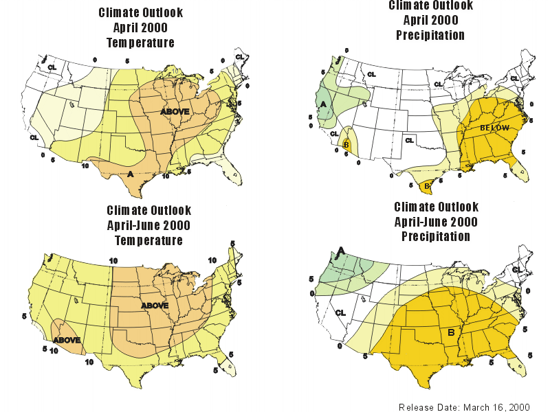
Fig.4. 30 and 90-day temperature and precipitation forecast maps (April and April to June 2000)
(Source: National Weather Service, Boise, Idaho)
Keetch-Byram Drought Index (KBDI) by Florida’s Division of Forestry / Forest Protection Bureau
John Keetch and George Byram developed the K/B index at the Southern Forest Fire Laboratory to evaluate the effects of long-term drying on litter and duff and subsequently, on fire activity (1968). The index is based on a measurement of 8 inches (20 cm) of available moisture in the upper soil layers that can be used by vegetation for evapotranspiration. The index measure is in hundredths (0.01) of an inch of water and has a range of 0 through 800, with 0 being saturated and 800 representing the worst drought condition. The index indicates deficit inches of available water in the soil. A K/B reading of 250 means there is a deficit of 2.5 inches (64 mm) of ground water available to the vegetation. As drought progresses, there is more available fuel that can contribute to fire intensity.
For further information on the KBDI please refer to Keetch-Byram Drought Index Revisited: Prescribed Fire Applications.

Fig.5. Keetch-Byram Drought Index Map of Florida, 16 April 2000
(Source: Florida Division of Forestry)
The Southern Area Coordination Center Morning Report (16 April 2000) is a narrative summary of fire activity within the Southern Area including number of fires, wildfires as well as prescribed burns, and area. (For detailed numbers of wildfires and prescribed burns, please refer to the original website of the report.)
SOUTHERN AREA:
Southern Area Coordination Center: Fire danger is low throughout most of the Area. Wet and sloppy weather is predicted for much of the South.
ALABAMA:
Alabama Interagency Coordination Center: No information received. Partly cloudy weather is predicted.
ARKANSAS/OKLAHOMA:
Arkansas/Oklahoma Interagency Coordination Center: No information received. Warmer temperatures occurring through Saturday, scattered thunderstorms through weekend.
Buffalo National River: Prescribed burn module remains committed to South Dakota.
FLORIDA:
Florida Interagency Coordination Center: A couple of orders remain open. No information obtainable from the Merritt Fire, incident is still demobing. Morning fog is expected in some areas. Possible severe thundershowers predicted for South Florida.
Florida Division of Forestry: MERRITT FIRE This 15,400-acre fire is located southeast of Naples. 95% contained. Fire line being constructed.
GEORGIA:
Georgia Interagency Coordination Center: Partly cloudy today with increasing clouds and chance of thundershowers Sunday night and Monday.
KENTUCKY:
Kentucky Interagency Coordination Center: Reported no fire activity. A day of moderate drying was recorded across the Commonwealth. Partly cloudy and mild conditions are forecast for Saturday with a 30% chance of showers.
LOUISIANA:
Louisiana Interagency Coordination Center: No fire activity. Skies are partly cloudy.
MISSISSIPPI:
Mississippi Interagency Coordination Center: No information received. Patchy AM fog expected. Scattered showers and thunderstorms are possible this afternoon.
NORTH CAROLINA:
North Carolina Interagency Coordination Center: No information received. Skies are partly cloudy.
SOUTH CAROLINA:
South Carolina Interagency Coordination Center: No information received. Scattered clouds will last through the day.
TENNESSEE:
Tennessee Interagency Coordination Center: No information received. Chance of showers and thunderstorms is increasing tonight and Monday.
TEXAS:
Texas Interagency Coordination Center: No information received. Weather is partly cloudy with a slight chance of thundershowers.
VIRGINIA:
Virginia Interagency Coordination Center: No information received. Skies are partly cloudy.
According to the Incident Management Situation Report three categories of fires are distinguished, such as:
1. Fires*
2. Prescribed Fires
3. Wildland Fire Use Fires**
* This classification corresponds to the category “wildland fires” as defined by the National Interagency Fire Center (NIFC)
** A brief excursion to wildland fire terminology:
Wildland Fires: Fires occurring on any tpye of vegetation, regardless of ignition sources, damages or benefits.
Wildfire: Any uncontrolled wildland fire which (1) may require suppression response, or (2) any uncontrolled wildland fire which meets management objectives and is declared as a Wildland Fire Use Fire (see below) or syn. Prescribed Natural Fire or Prescribed Fire.
Prescribed Fire: Occasionally also called management-ignited fire, or prescribed burning, is a controlled application of fire to vegetation in either their natural or modified state, under specified environmental conditions which allow the fire to be confined to a predetermined area and at the same time to produce the intensity of heat and rate of spread required to attain planned resource management objectives.
Wildland Fire Use Fire: Naturally ignited fire which is managed to achieve resource benefits under close supervision (syn. Prescribed Natural Fire)
Incident Management Situation Report (14 April 2000):
Current Situation:
One new large fire was reported in northern Arizona. The weather assisted with progress on the large fire in Florida. Initial attack activity was minimal nationwide. Very high to extreme fire indices were reported in Arizona, New Mexico, Utah, California, Texas, Kansas and Virginia.
Outlook:
A FIRE WEATHER WATCH IS POSTED TODAY FOR STRONG WINDS AND LOW HUMIDITIES IN ARIZONA AND NEW MEXICO
Arizona and New Mexico will be partly cloudy with a slight chance of afternoon showers and thunderstorms in the northern mountains.
Southwest winds will increase to between 20 and 30 mph. Minimum relative humidity will be in the teens. Temperatures will vary from the mid 60’s (15°C) in the mountains to the mid 90’s (32°C) in the southern deserts.
Florida will be mostly cloudy with showers and thunderstorms throughout the state. Temperatures will be in the 70’s (20°C) in the north up to the low 80’s (25°C) in the south. Winds will be east to southeast at 5 to 15 mph.
Detailed information and data about fires, prescribed fires, wildland fire use fire and burned areas (14 April 2000) for all geographic areas of the United States can begathered from the Incident Management Situation Report.
Remarks on Prescribed Burning
At this time of the year prescribed burning operations are conducted routinely.
Fire is an important natural tool for ecosystem management. It can reduce dense vegetation improving wildlife habitat and lessening the potential for large, wildfire disasters. Land managers are directed to prepare a prescribed fire/burn plan for every area of public land that can burn. Some areas require total suppression while others will benefit from a wildland fire. Those areas that will benefit from a fire can be treated by a prescribed fire.
Especially, for the moment, in the southern and southeastern regions of the United States prescribed fire activities will be carried out in the following weeks and months. In this case, fire signals on satellite images can be traced back to this kind of land management activities.
In the Prescribed Fire Position Paper of the Forest Protection Bureau by the Division of Forestry in Florida, prescribed fire activity is described as a land management application that is essential to the practice of forestry, management of wildlife, preservation of endangered plant and animal species, improvement of range conditions and reduction of wildfire damage in the wildland/urban interface areas. While there is general public and landowner concern with increased smoke, reduced air quality, and liability; the general public and landowners benefit significantly from the reduction of devastating wildfire, improved wildlife habitat and forage, preservation of endangered and threatened plant and animal species, and improved management of forest resources. The prospect of severe reductions in the utilization of this management tool is of major concern to Florida’s natural resource managers and conservationists due to the subsequent loss of derived public and private benefits. They suggest the need for legislative attention.
Another report on nation-wide prescribed burning in the U.S.A. was published in International Forest Fire News No.19 (September 1998).
A set of photographic documents on prescribed burning techniques and objectives in the Southeast can be visited in our photo archive.
