Meteorological Conditions in South East Asia: 2 November 1999
Meteorological Conditions in SouthEast Asia
2 November 1999
The Meteorological Service of Singapore reports on 1 November 1999 for the South East Asian region: “Cloudy conditions over northern and southern Sumatra and many parts of Kalimantan. The region is generally clear of smoke haze.”

Fig.1. Regional Surface Winds and Haze/Hot Spot Map, 1 November 1999
(Source: http://www.gov.sg/metsin/hazed.html)
Forecasts of winds and surface pressure are available at http://www.gov.sg/metsin/flm.html
The GFMC displays selected and daily updated global and Asia-Pacific Experimental Climate Prediction Center (ECPC) Fire Weather Forecasts (Fig.1-6). These examples allow a quicklook and provide daily and weekly total forecasts, and forecasted monthly anomalies (for next month). For background information refer to the ECPC products description page.


tomorrow this week next month
Fig.2.-7. Fire Weather Index (FWI) forecast for tomorrow (left), next week (center) and the predicted FWI anomaly for next month (right) for the Western Pacific and the Pacific Ocean. The daily forecast refers to 12:00 hrs noon UTC (Greenwich) time; the weekly total forecast and the monthly forecasted anomaly refer to 00:00 hrs UTC which is local noon at dateline (180° longitude). Forecast time is 12:00 hrs noon UTC (Greenwich) corresponding to local evening time in mainland and insular SE Asia (updated: 2 November 1999).
(Source: http://meteora.ucsd.edu/ecpc/)
The ASEAN Haze Action Online provides the following information:
- Monitoring: Hyperlinks to institutions involved in regional monitoring and prediction of fire and smoke haze
- Haze News: ASEAN Transboundary Haze Update (updated daily)
- Intranet: Information and possible participation in the ASEAN Haze Action Online Intranet Information Services (for associated registered participants)
- Mobilization Plan: Model Fire Suppression Mobilization Plan
- Inventory: Inventory and analysis of forest and land fire suppression capabilities
- Haze Forum: Communication platform on fire and smoke-haze issues in the ASEAN region
- Calendar: Fire and haze-related events can be identified by a search modus
The ASEAN Fire Weather Information System (ASFWIS) is a co-operation between ASEAN and the Canadian Forest Service. It provides maps describing the current fire weather situation in South East Asia. This system is based upon the Canadian Forest Fire Danger Rating System (CFFDRS) (for further infomation to the CFFDRS refer to ASFWIS). Studies have shown that the CFFDRS is applicable outside of Canada. Currently it is also used in a modified form in New Zealand (see References). In New Zealand the Fire Weather Indices Fine Fuel Moisture Code (FFMC) and the Initial Spread Index (ISI) represent the fire danger in the scrublands. The Duff Moisture Code (DMC) is also applicable in South East Asia, because it potentially describes the moisture state of the upper peat layers in peat and peat swamp forests. All three parameters may serve as a suitable indicator of forest fire danger in South East Asia.
According to the ASFWIS for 28 October 1999 various fire weather parameters are shown in output maps for South East Asia.
The Forest Fire Prevention and Control Project (FFPCP) in Palembang (Sumatra) provides a fire overview map on the 1 November 1999.

Fig.8. Fire Overview Map for 1 November 1999 of the FFPCP project in Palembang.
(source: http://www.mdp.co.id/ffpcp/overview.htm)
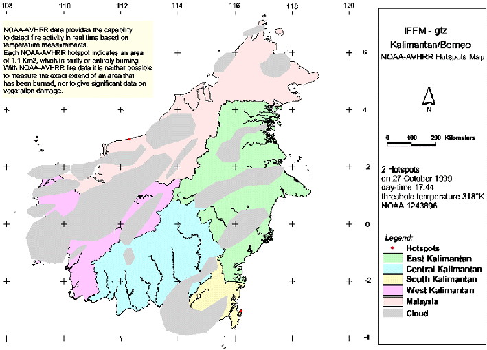
The newest fire overview map for the Integrated Forest Fire Management (IFFM) project in Kalimantan shows hotspots on the 27 October 1999.
The Indonesian Meteorological Agency Badan Meteorologi dan Geofisika publishs the Indonesia Daily Forecasting for 3 November 1999. For the representative selected areas metereological data are provided as follows:
Palembang Samarinda Dili Bandung Weather condition rain rain cloudy rain Temperature (min-max °C) 24-32°C 23-31°C 24-33°C 19-28°C Humidity (min-max %) 60-98 63-97 55-90 63-94
Summary: Although the current fire weather conditions do under normal conditions not favour extensive land clearing by fire or escaping wildfires in Indonesia, the consequences of the large wildfires of 1997-98 must been taken into consideration. These fires had caused extensive degradation of primary and secondary forests along with the spreading of “alang-alang” (Imperata cylindrica) grasslands. These grasslands facilitate the spread of uncontrolled fires over large areas.
See also the IFFN Country Notes.
