The Meteorological Service of Singapore reports on 09 July 2002 for the South East Asian region: "Most parts of Kalimantan and Sumatra remained fair and dry. More hot spots and smoke plumes were detected over central Sumatra. Few hot spots were seen in Peninsular Malaysia and Kalimantan." Forecasts of winds and surface pressure are also available.

Regional Surface Winds and Haze/Fire Map, 09 July 2002
(Source: Meteorological Service of
Singapore)
Review of Regional Weather and Smoke Haze
Some pockets of dry weather have started to develop over northern and central Sumatra and over a larger part of the northern half of Borneo in
January as the northeast monsoon rain-belt progresses further south of the Equator over Southern Sumatra and Java island.
The number of hot spots, however, was small on most days.
(SOURCE: Meteorological Service of Singapore)

Daily Hot Spots Counts over Kalimantan from June to July 2002
(Source: Meteorological Service of
Singapore)

Daily Hot Spots Counts over Sumatra from June to July 2002
(Source: Meteorological Service of
Singapore)
Weather and Haze Outlook
(Meteorological Service of
Singapore 10 July 2002)
"The inflow of Southwest Monsoon winds has heralded the onset of the
traditionally dry season in the region. With the continued expectation of a
weak El Nino in the second half of the year, increased occurrences of forest
fires and smoke haze can be expected over Indonesia and Kalimantan in the
coming few months. At this stage, while periodic haze can be expected, the
chance of a recurrence of the 1997-type severe prolonged widespread smoke
episode is assessed to be low."
See also: El
Niño Outlook by WMO and IRI (27 March 2002)
The Meteorological Service of Singapore provides rainfall-record charts for selected locations in Sumatra and Kalimantan with information about the mean annual rainfall and the actual monthly and weekly records for last year.
 |
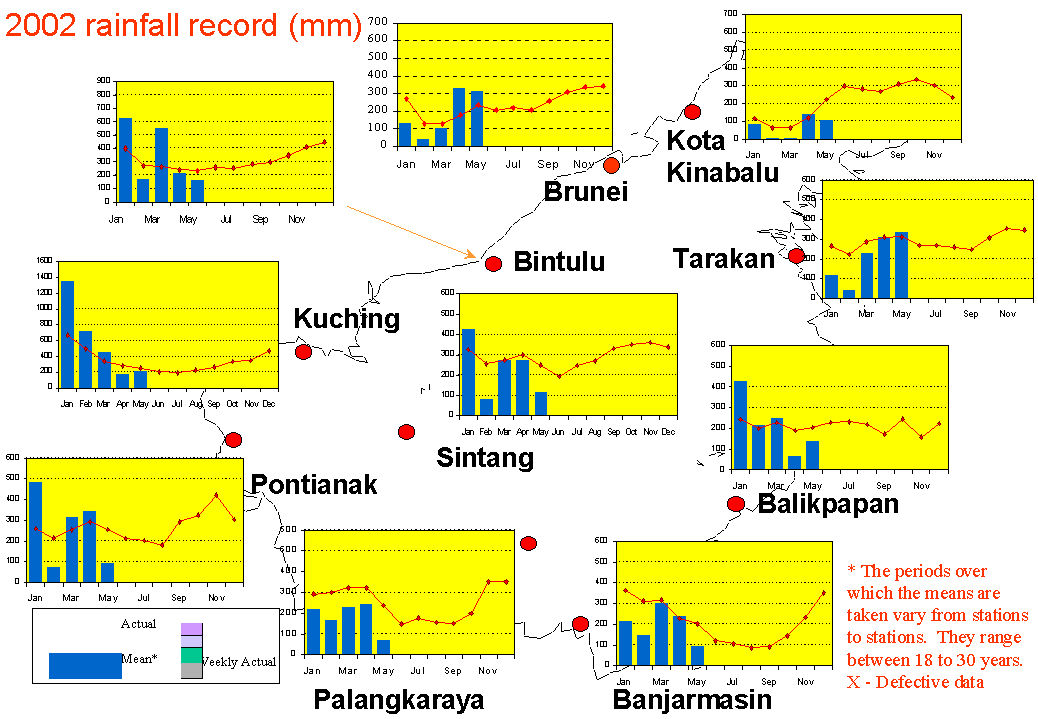 |
Rainfall charts for Sumatra and Kalimantan
(Source: Meteorological Service of
Singapore)
The GFMC displays selected and daily updated global and Asia-Pacific Experimental Climate Prediction Center (ECPC) Fire Weather Forecasts. These examples allow a quicklook and provide daily and weekly total forecasts and forecasted monthly totals. For background information refer to the ECPC products description page.
 |
 |
 |
 |
 |
|
| tomorrow | this week | this month |
Fire Weather Index (FWI) forecast for this
week (left) and the predicted
FWI total for next month (right) for the Western Pacific (1-3) and the Pacific
Ocean (4-6) regions.
The weekly total forecast and the monthly forecasted total refer to 00:00 hrs
UTC,
which is local noon at dateline (180° longitude). Forecast time is 12:00 hrs
noon UTC (Greenwich)
corresponding to local evening time in mainland and insular SE Asia.
(Source: ECPC
Fire Weather Index Forecast)
The ASEAN Fire Weather Information System (ASFWIS) is a co-operation between ASEAN and the Canadian Forest Service. It provides maps describing the current fire weather situation in South East Asia. This system is based upon the Canadian Forest Fire Danger Rating System (CFFDRS) (for further infomation to the CFFDRS refer to ASFWIS). Studies have shown that the CFFDRS is applicable outside of Canada. Currently it is also used in a modified form in New Zealand (see References). In New Zealand the Fire Weather Indices Fine Fuel Moisture Code (FFMC) and the Initial Spread Index (ISI) represent the fire danger in the scrublands. The Duff Moisture Code (DMC) is also applicable in South East Asia, because it potentially describes the moisture state of the upper peat layers in peat and peat swamp forests. All three parameters may serve as a suitable indicator of forest fire danger in South East Asia.
The updated ASFWIS maps show fire weather, fuel conditions and fire behaviour parameters for South East Asia:
 |
 |
 |
|
Fine Fuel Moisture Code |
Duff Moisture Code |
Drought Code |
 |
 |
 |
|
Initial Spread Index |
Buildup Index |
Fire Weather Index |
Output maps of the ASFWIS, 09 July 2002
(Source: ASFWIS)
South East Asia
Fire Monitoring by ANDES
The Asia Pacific Network for Disaster Mitigation using Earth Observation
Satellite (ANDES) provides daily fire maps of mainland and insular South East
Asia. The latest maps can be accessed through the ANDES
website. The map below shows the latest fire map of mainland SE Asia
(Thailand, Myanmar, Lao, Cambodia, Viet Nam).

ANDES
fire location map of mainland SE Asia
Date: 09 July 2002. The map is generated on the basis of two satellite sensors
(NOOA-AVHRR, DMSP/OLS).
Source: ANDES
The Forest
Fire Prevention and Control Project (FFPCP)
The Forest Fire Prevention
and Control Project (FFPCP) in Palembang (Sumatra) closed on 30 November 2001.
The South Sumatra Forest Fire Management Project (SSFFMP) is expected to start
within the second half of the year 2002 and will continue the work of FFPCP.
Meanwhile the daily fire map (hot-spot) and monthly drought index for Sumatra
will continue to be updated from time to time.

Fire overview map for Sumatra (09 July 2002)
(Source: FFPCP)
Haze
Prevention Group
The industrial initiative to combat haze in SE Asia provides a website which includes information about the
objectives of this industrial initiative and projects implemented
to reduce wildfires and haze in Indonesia.
The ASEAN Haze Action Online provides the following information:
- Monitoring: Hyperlinks to institutions involved in regional monitoring and prediction of fire and smoke haze
- Haze News: ASEAN Transboundary Haze Update (updated daily)
- Intranet: Information and possible participation in the ASEAN Haze Action Online Intranet Information Services (for associated registered participants)
- Mobilization Plan: Model Fire Suppression Mobilization Plan
- Inventory: Inventory and analysis of forest and land fire suppression capabilities
- Haze Forum: Communication platform on fire and smoke-haze issues in the ASEAN region
- Calendar: Fire and haze-related events can be identified by a search modus
The Integrated Forest Fire Management Project (IFFM) in Samarinda provides regulary updated hot spots maps of Kalimantan.