The Meteorological Service of Singapore reports on 14 March 2000 for the South East Asian region: "A few hot spots were detected in central Sumatra. Cloudy and wet over most parts of Kalimantan." Forecasts of winds and surface pressure are also available.

Fig. 1. Regional Surface Winds and Haze/Hot Spot Map,
14 March 2000
(Source: Meteorological Service of Singapore)
The latest NOAA14 satellite image show hot spot location in Sumatra. "Hot spots" can be identified as red dots.
 |
Fig.2. Latest NOAA Satellite images of
Sumatra, 13 March 2000
(Source: Meteorological Service of Singapore)
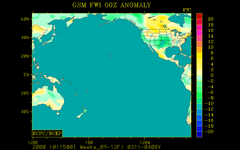
The GFMC displays selected and daily updated global and Asia-Pacific Experimental Climate Prediction Center (ECPC) Fire Weather Forecasts (Fig.2-7). These examples allow a quicklook and provide daily and weekly total forecasts, and forecasted monthly anomalies (for this month). For background information refer to the ECPC products description page.
| today not available | 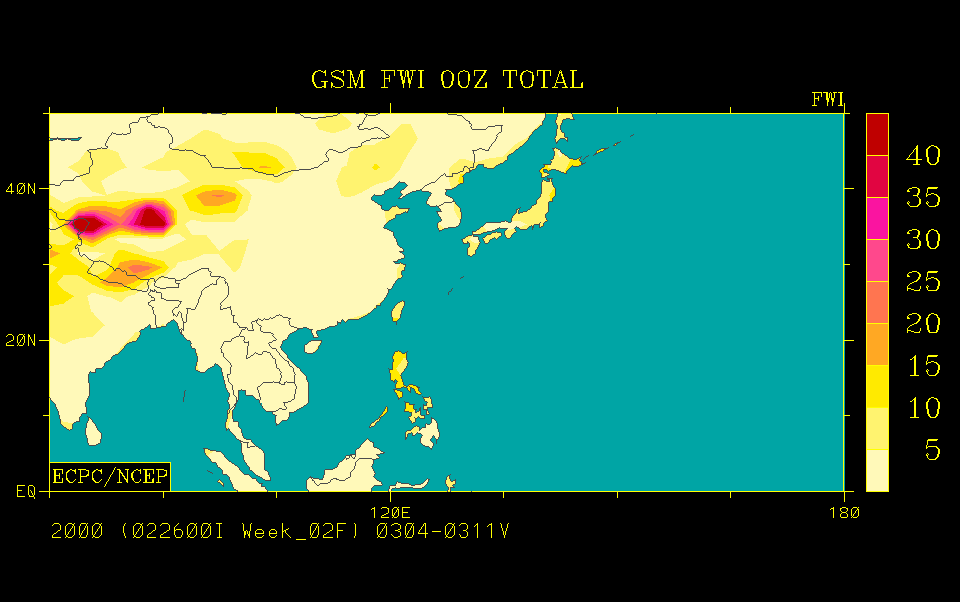 |
 |
| today not available | 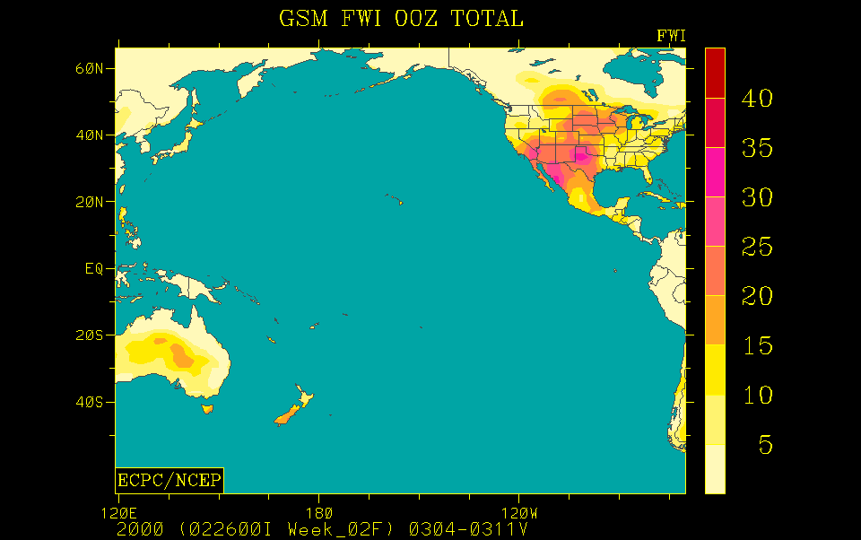 |
 |
| tomorrow | this week | this month |
Fig.3.-8. Fire Weather Index (FWI)
forecast for tomorrow (left), this week (center) and the predicted FWI anomaly for this
month (right) for the Western Pacific and the Pacific Ocean. The daily forecast refers to
12:00 hrs noon UTC (Greenwich) time; the weekly total forecast and the monthly forecasted
anomaly refer to 00:00 hrs UTC, which is local noon at dateline (180° longitude).
Forecast time is 12:00 hrs noon UTC (Greenwich) corresponding to local evening time in
mainland and insular SE Asia (updated: 2 March 2000, currently there is
no update available).
(Source: ECPC)
The ASEAN Fire Weather Information System (ASFWIS) is a co-operation between ASEAN and the Canadian Forest Service. It provides maps describing the current fire weather situation in South East Asia. This system is based upon the Canadian Forest Fire Danger Rating System (CFFDRS) (for further infomation to the CFFDRS refer to ASFWIS). Studies have shown that the CFFDRS is applicable outside of Canada. Currently it is also used in a modified form in New Zealand (see References). In New Zealand the Fire Weather Indices Fine Fuel Moisture Code (FFMC) and the Initial Spread Index (ISI) represent the fire danger in the scrublands. The Duff Moisture Code (DMC) is also applicable in South East Asia, because it potentially describes the moisture state of the upper peat layers in peat and peat swamp forests. All three parameters may serve as a suitable indicator of forest fire danger in South East Asia.
According to the ASFWIS for 11 March 2000 different parameters show various fire weather conditions over South East Asia.
The ASEAN Haze Action Online provides the following information:
- Monitoring: Hyperlinks to institutions involved in regional monitoring and prediction of fire and smoke haze
- Haze News: ASEAN Transboundary Haze Update (updated daily)
- Intranet: Information and possible participation in the ASEAN Haze Action Online Intranet Information Services (for associated registered participants)
- Mobilization Plan: Model Fire Suppression Mobilization Plan
- Inventory: Inventory and analysis of forest and land fire suppression capabilities
- Haze Forum: Communication platform on fire and smoke-haze issues in the ASEAN region
- Calendar: Fire and haze-related events can be identified by a search modus
The Forest Fire Prevention and Control Project (FFPCP) in Palembang (Sumatra) provides a fire overview map for the 10 March 2000.
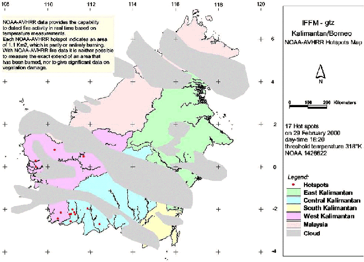
The last available fire overview map (29 February 2000) of the Integrated Forest Fire Management (IFFM) project in Kalimantan shows 17 HTE's (hot spots).
The Indonesian Meteorological Agency Badan Meteorologi dan Geofisika publishs the Indonesia Daily Forecasting for 15 March 2000. For the representative selected areas metereological data are provided as follows:
| Palembang | Samarinda | Bandung | |
| Weather condition | rain | rain | rain |
| Temperature (min - max °C) | 22 - 31 | 23 - 32 | 19 - 28 |
| Humidity (min - max %) | 64 - 97 | 60 - 93 | 60 - 93 |
Planet Ark posted the following article yesterday
UN agency worried about repeat of SE Asian haze (13 March
2000)
BANGKOK - The United Nations Environment Programme (UNEP) expressed concern on Friday that
fires erupting in Indonesia may cause a repeat of a haze which smothered parts of
Southeast Asia in 1997 and 1998. But UNEP's Asia Pacific Director, Nirmal Andrews, told
Reuters he welcomed Indonesia's response to the forest fires on Sumatra island adding it
could avert another regional haze crisis.
"The Indonesian government's intention to summon logging and plantation company
owners and to review their licenses is the kind of tough measure needed to pre-empt
another crisis," he said. "These are early hot spots and strong steps can help
check the problem." Indonesia said it would publicly name and punish plantation
owners guilty of setting fires to clear land in Riau province as the smoke threatened
neighbouring Singapore and Malaysia. The country's Forestry Department said investigators
had found a major fire in a palm plantation owned by a Malaysian company and would name
and punish guilty companies soon but environmentalists say Indonesia's laws lacked teeth.
Andrews said about 1,200 fires had been detected in Sumatra and Kalimantan earlier this
week with pollution readings over the 300 level on the Pollution Standard Index (PSI), a
level considered hazardous to health.Widespread fires in 1997 in Sumatra and the
Indonesian province of Kalimantan, on Borneo island, caused thick smoke to engulf
Singapore and parts of Malaysia, causing health problems and damaging the tourist
industry. An early warning system, supported by UNEP and other regional agencies and
governments, uses high-resolution satellite imagery to detect specific land holdings where
there are hot spots. It also allows for quick and coordinated mobilisation of fire
fighting teams.
Singapore's air condition worsened to the most polluted levels of the year
late on Wednesday when its PSI stood at 65. An air-quality rating of 0-50 is considered
good, 51-100 moderate and 101-200 unhealthy. Environmentalists in Malaysia expect the
country to feel the effects of the haze if the fires persist.
Summary: Although the current fire weather conditions do under normal conditions not favour extensive land clearing by fire or escaping wildfires in Indonesia, the consequences of the large wildfires of 1997-98 must been taken into consideration. These fires had caused extensive degradation of primary and secondary forests along with the spreading of "alang-alang" (Imperata cylindrica) grasslands. These grasslands facilitate the spread of uncontrolled fires over large areas.
See also the IFFN Country Notes.