The Meteorological Service of Singapore reports on 9 September 1999 for the South East Asian region: "Cloudy conditions over central and northern Sumatra. Hot Spots with smoke haze areas were observed maily in Kalimantan."

Fig.1. Regional Surface Winds and Haze/Hot Spot Map, 9
September 1999
(Source: http://www.gov.sg/metsin/hazed.html)
Forecasts of winds and surface pressure are available at http://www.gov.sg/metsin/flm.html
The GFMC displays selected and daily updated global and Asia-Pacific Experimental Climate Prediction Center (ECPC)
Fire Weather Forecasts (Fig.2-7). These examples allow a quicklook and provide
daily and weekly total forecasts, and forecasted monthly anomalies (for next month). For
background information refer to the ECPC products
description page.
 |
 |
 |
 |
 |
 |
| tomorrow | next week | next month |
Fig.2-7. Fire Weather Index (FWI)
forecast for tomorrow (left), next week (center) and the predicted FWI anomaly for next
month (right) for the Western Pacific and the Pacific Ocean. The daily forecast refers to
12:00 hrs noon UTC (Greenwich) time; the weekly total forecast and the monthly forecasted
anomaly refer to 00:00 hrs UTC which is local noon at dateline (180° longitude). Forecast
time is 12:00 hrs noon UTC (Greenwich) corresponding to local evening time in mainland and
insular SE Asia (updated: 10 September 1999).
(Source: http://meteora.ucsd.edu/ecpc/)
The ASEAN Haze Action Online provides the following information:
- Monitoring: Hyperlinks to institutions involved in regional monitoring and prediction of fire and smoke haze
- Haze News: ASEAN Transboundary Haze Update (updated daily)
- Intranet: Information and possible participation in the ASEAN Haze Action Online Intranet Information Services (for associated registered participants)
- Mobilization Plan: Model Fire Suppression Mobilization Plan
- Inventory: Inventory and analysis of forest and land fire suppression capabilities
- Haze Forum: Communication platform on fire and smoke-haze issues in the ASEAN region
- Calendar: Fire and haze-related events can be identified by a search modus
The latest NOAA14 satellite images show hot spot locations in Sumatra and Kalimantan. "Hot spots" can be identified as red dots.
 |
 |
Fig.8.-9. Latest NOAA Satellite images
of Sumatra and Kalimantan, 8 September 1999
(Source: http://www.gov.sg/metsin/hazed.html)
The Forest Fire Prevention and Control Project (FFPCP) in Palembang (Sumatra) provides a fire overview map on 8 September 1999.

Fig.10. Fire Overview Map for 8 September 1999 of the
FFPCP project in Palembang.
(source: http://www.mdp.co.id/ffpcp/overview.htm)
The newest fire overview map for the Integrated Forest Fire Management (IFFM) project in Kalimantan shows 116 hotspots on the 9 September 1999.
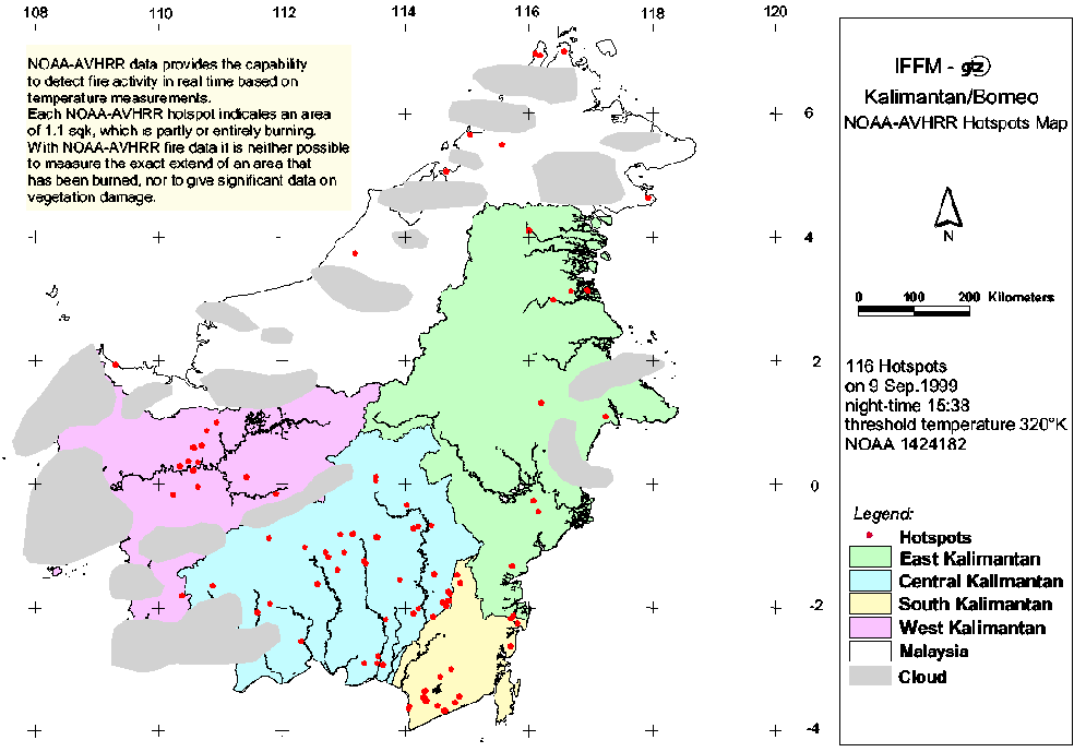
Fig.11. Fire Overview Map for 9 September 1999 of the
IFFM project in Samarinda
(Source: http://www.iffm.or.id/hotspots_map.htm)
Summary: Although the current fire weather conditions do under normal conditions not favour extensive land clearing by fire or escaping wildfires in Indonesia, the consequences of the large wildfires of 1997-98 must been taken into consideration. These fires had caused extensive degradation of primary and secondary forests along with the spreading of "alang-alang" (Imperata cylindrica) grasslands. These grasslands facilitate the spread of uncontrolled fires over large areas.
See also the IFFN Country Notes.