Meteorological Conditions in South East Asia: 22 May 1999
Meteorological Conditions in SouthEast Asia
22 May 1999
The Meteorological Service of Singapore reports on 22 May 1999 for the South East Asian region: “Partly cloudy with isolated showers over parts of Sumatra and Kalimantan. No hot spots or smoke haze were observed in the region”.

Fig.1. Regional Surface Winds and Haze/Hot Spot Map, 22 May 1999
(Source: Meteorological Service of Singapore)
The ASEAN Fire Weather Information System (ASFWIS) is a co-operation between ASEAN and the Canadian Forest Service. It provides maps describing the current fire weather situation in South East Asia. This system is based upon the Canadian Forest Fire Danger Rating System (CFFDRS) (for further infomation to the CFFDRS refer to ASFWIS). Studies have shown that the CFFDRS is applicable outside of Canada. Currently it is also used in a modified form in New Zealand (see References). In New Zealand the Fire Weather Indices Fine Fuel Moisture Code (FFMC) and the Initial Spread Index (ISI) represent the fire danger in the scrublands. The Duff Moisture Code (DMC) is also applicable in South East Asia, because it potentially describes the moisture state of the upper peat layers in peat and peat swamp forests. All three parameters may serve as a suitable indicator of forest fire danger in South East Asia.
According to the ASFWIS for 21 May 1999 these parameters show various fire weather conditions over South East Asia. The Fine Fuel Moisture Code (FFMC) is high in Java and Sumatra.


Fig.2., 3. and 4. FFMC, ISI and DMC output of the ASFWIS, 21 May 1999
The Indonesian Meteorological Agency Badan Meteorologi dan Geofisika publishs the Indonesia Daily Forecasting for 23 May 1999. For the representative selected areas metereological data are provided as follows:
Palembang Samarinda Ujung Pandang Dili Bandung Weather condition rain rain rain clear rain Temperature max (°C) 32°C 32°C 32°C 31°C 30°C Humidity (min-max %) 62-95 65-97 60-96 50-84 56-91
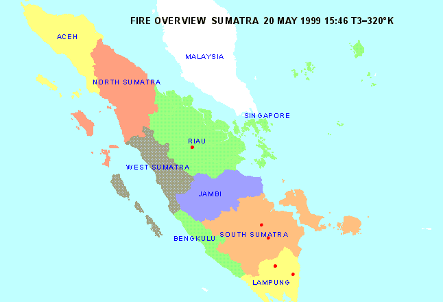
The Forest Fire Prevention and Control Project (FFPCP) in Palembang (Sumatra) provides a fire overview map on 20 May 1999.
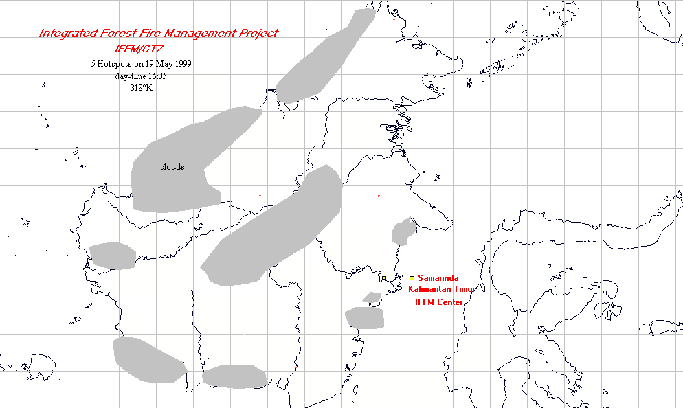
The newest fire overview map for the Integrated Forest Fire Management (IFFM) project in Samarinda (East Kalimantan) shows five hot spots for the 19 May 1999.
Summary: Although the current fire weather conditions do under normal conditions not favour extensive land clearing by fire or escaping wildfires in Indonesia, the consequences of the large wildfires of 1997-98 must been taken into consideration. These fires had caused extensive degradation of primary and secondary forests along with the spreading of “alang-alang” (Imperata cylindrica) grasslands. These grasslands facilitate the spread of uncontrolled fires over large areas.
See also the IFFN Country Notes.
