Chile: 11 February 1999 (09:00 UTC)
11 February 1999 (09:00 UTC)
Several active fire signals and smoke plumes are recorded by OSEI with the NOAA AVHRR Sensor on 10 February 1999.
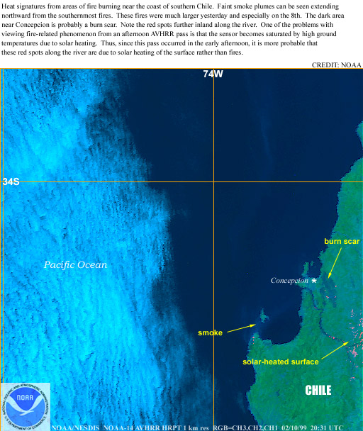
Fig.1. NOAA AVHRR image of the vegetation fires in Chile near Concepción 10 February 1999
(Source: NOAA http://www.osei.noaa.gov/ )
The fires currently burning near Concepción, Region Bío-Bío, Chile, are located in a region where agricultural and grazing lands are found as well as
extended pine plantations. Today there is no smoke plume visible on the imagery. The imagery shows the possible fire scar (area burned) which still
needs to be verified by the local experts.
The forest fire near Concepción began on Sunday 7 February 1999. As Mr. Herbert Haltenhoff, Chief of the National Fire Prevention Programme of Chile, reports, a total of 24 simultaneous forest fires have meanwhile burned more than 28.000 ha. The type of vegetation affected is: plantations Radiata pine (30%), natural forest (20%), brush (40%) and grassland (10%) (preliminary figures). In addition, nearly 60 rural houses, 1 school, and other constructions were lost.
Until yesterday more than 800 firefighters of the Forest Srvice of Chile (Corpoación Nacionál Forestál [CONAF]), Forestry Companies, City firemen, and military were involved in fire suppression. They were supported by 8 helicopters and 5 air tankers.
All fires were caused by humans (use of fire in forest and agricultural activities, campfire, and arson). The current forest fire season is the more critical than the last time. Chile is currently suffering the worst dry season in the last 60 years.
Tab.1. National fire occurrence and burned areas in Chile1994 – 1999
(Until 9 February 1999)
FIRE SEASON
FIRES
PLANTATIONS
(ha)
NATURAL FOREST
OTHERS AREAS
TOTAL
(ha)
AVERAGE (ha/Fire)
1993/94
2.563
1.977,17
28.532,69
830,86
31.340,72
12,23
1994/95
2.175
1.259,20
10.461,76
1.028,53
12.749,49
5,86
1995/96
2.971
2.600,51
17.227,80
2.564,27
22.392,58
7,54
1996/97
1.947
2.438,17
6.175,50
1.717,23
10.330,90
5,31
1997/98
2.045
1.179,81
10.419,95
404,52
12,004.28
5,87
Average
2.340
1.890,97
14.563,54
1.309,08
17.763,59
7,59
1998/99
3.121
2.716,03
35.919,37
2.117,71
40.753,11
13,06
Note: Not including the fire in the Concepción area which burned 28.000 to 30.000 ha until today.
Contact in Chile:
Herbert Haltenhoff D.
Chief, National Fire Prevention Program
Fire Management Department
National Forestry Corporation
E-mail: hhaltenh@conaf.cl
Santiago
CHILE
Additional background information: According to the 10-year fire statistics (1989-98) the fires causes in Chile are: transiting people (30%), intentionally set (29%), forest slash burning (7%), agricultural burining (7%), unknown (13%).
For some older fire analyzes and statistics: See International Forest Fire News. Photographic impressions of fires in Chile are provided in the Photo Archive.
A more recent report was presented in Brazil in 1998:
Sanhueza, Patricio I. 1998. Cooperación de los sectores public y privado en el control de los incendios forestales en Chile: Organización e integración: Claves para un buen resultado. Presented at the First South American Seminar/Fifth Tech. Meeting on the Control of Forest Fires, Belo Horizonte, Minas Gerais, Brazil, 29 June to 2 July 1998.
