28 July 2000
The Canadian Interagency Forest Fire Centre (CIFFC) distributes timely information about forest fires in Canada. The current fire situation for 27 July 2000 can be summarized as follows:
| over the last 24 hours: | 87 fires for 3,785 ha |
| season summary: | 3,320 fires for 231,406 hectares |
According to the National Forest Fire Situation Report of 19 July 2000 (updated every Friday), that the area burned is 11% of normal, due to continuing wet weather in much of the country. High fire risk is in British Columbia and the northwest, with warmer and drier weather over much of the country expected to increase risk in all regions.
Number and area of forest fires in Canada, as of 19 July 2000
| current | uncontrolled | controlled | active modified | |
| 2 | 90 | 96 | ||
| 2000 (to date) |
10-year average |
in % of normal |
Prescribed burning |
|
| Number | 2,808 | 4,907 | 57% | 40 |
| Area (ha) | 148,964 | 1,365,929 | 11% | 7,863 |
The Fire Monitoring, Mapping, and Modelling (FireM3) is a collaboration of the Canadian Forest Service and the Canada Centre for Remote Sensing. Through the Map Link at the FireM3 web site you can access daily hotspot images. An Internet Map Server, which is like a simple GIS running on the host computer, allows you to zoom in on any fire or other area of interest and view the image and map data at full (1 km) resolution. You can also click on any fire and get information about that fire.
 |
 |
 |
Satellite image, daily fire overview map and
season-to-date hotspot map for 26 July 2000
(Source: FireM3)

The satellite image is showing hotspots from fires in Newfoundland from
26 July 2000.
(Source: FireM3)
The Canadian Forest Fire Weather Index (FWI) System is a part of the Canadian Wildland Fire Information System and consists of six components that account for the effects of fuel moisture and wind on fire behavior. The first three components are fuel moisture codes and are numerical ratings of the moisture content of litter and other fine fuels, the average moisture contentof loosely compacted organic layers of moderate depth, and the average moisture content of deep, compact organic layers. The remaining three components are fire behavior indexes which represent the rate of fire spread, the fuel available for combustion, and the frontal fire intensity; their values rise as the fire danger increases. For futher information please see the Summary Information.
The latest available images are shown below (27 July 2000):
 Fine Fuel Moisture Code |
 Duff Moisture Code |
 Drought Code |
 Initial Spread Index |
 Buildup Index |
 Fire Weather Index |
 Fire Danger Rating |
The Canadian Forest Fire Behavior Prediction (FBP) System is an other part of the Canadian Wildland Fire Information System and provides quantitative estimates of head fire spread rate, fuel consumption, fire intensity, and fire description. With the aid of an elliptical fire growth model, it gives estimates of fire area, perimeter, perimeter growth rate, and flank and back fire behavior. For futher information please see the Summary Information.
The latest available images are shown below (27 July 2000):
 Foliar Moisture Content |
 Surface Fuel Consumption |
 Rate of Spread |
 Total Fuel Consumption |
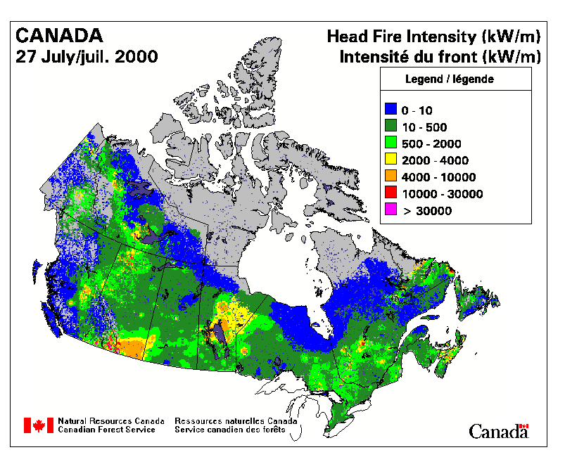 Head Fire Intensity |
 Fire Type |
The Saskatchewan Daily Forest Fire Situation Report (27 July 2000) is listing all forest fires currently burning in Saskatchewan and their current status. This report also gives statistics on the total number of fires to date. The whole report and further information can be accessed at the fire management website of "Saskatchewan Environment and Resource Management" (SERM).
| fires burning in the province today: | 16 |
| extinguished in the past 24 hours: | 1 |
| new fires: | 1 |
| total number of fires to date this year: | 328 |
| total up to this date last year: | 555 |
| five year average for this date: | 546 |
British
Columbia Forest Service Wildfire Report (27 July 2000):
Officials are cautiously optimistic about U.S. blaze
Senior B.C. forestry officials finished their risk assessment today of the
3,800-hectare Rocky Hull wildfire burning southeast of Oroville, Washington. The wildfire,
burning since Saturday, is estimated to be within 10 kilometres of the border. There are
over 1,000 U.S. firefighters battling the blaze, and agreements are in place to allow
further assistance from the B.C. Forest Service, which provided air tanker support earlier
this week. With warm temperatures and dry conditions, this fire continues to be active.
However, forestry officials are cautiously optimistic that the fire will be fully
contained before becoming a threat to B.C. Fire officials in the Kamloops Fire Centre have
developed a good working relationship with their counterparts in Washington State and have
continued regular cross-border meetings. A strategy and contingency plans are in place,
and the Forest Service will continue to monitor this fire closely. The southern Okanagan
is an area where there is continual concern about the risk of wildfire threat to populated
areas. The fire danger rating continues to be high in this area.
Wildfire Statistics Report, 27 July 2000
| Number of Fires Burning: | 137 |
| Number of New Fires (Lightning): | 13 |
| Number of New Fires (Human Caused): | 5 |
| Total Lightning Fires: | 299 |
| Total Human Caused Fires: | 392 |
| Total Fires to Date: | 691 |
| Total Area Burned (ha): | 12,535 |

Fire Danger Rating for British Columbia, 27 July 2000.
(Source: British
Columbia Forest Service)
The International Crown Fire Modelling Experiment (ICFME) in Fort Providence, Northwest Territories/Canada, ended with its final chapter, Phase IV, on 1 July 2000. During the experimental phases a special ICFME website was updated daily. A new archive about
- 2000 daily updates
- a list of fire research and operational people and
- social hi-lites from Ft. Providence during the experiment
is available on the ICFME website. The experiment has been also described in the International Forest Fire News (IFFN) No. 21 (September 1999).