Croatia: Forest Fires in Croatia – A Permanent Danger (IFFN No. 9 – July 1993)
Forest Fires in Croatia – A Permanent Danger
(IFFN No. 9 – July 1993, p. 13-15)
Forests and other wooded land cover about 35% (ca. 2,458,000 ha) of the total land area of Croatia. In terms of phytogeographic diversity, there are two forest regions: Euro-Siberian and Mediterranean. The Mediterranean forest region covers 43% of the total forest area. Forest fire occurrences, affected areas, and related damages are closely connected to our Mediterranean forests and their degraded stages (maquis, coppice, garrigue, brushwood). 94% (ranging from 89 to 99%) of the total area affected by the fire was in the karst region (Tab.1 and 2). The forest fire season has two peaks. The first one is between March and May. In this period forest fires are mainly a direct consequence of agricultural waste burning without taking the necessary precautions on nonforest land. The second peak (time of large fires) coincides with extreme weather conditions and high tourist frequency (Tab.3).
According to forest fire data of the last 20 years, we can say that 99,9% are due to human activities, but about 50% are ascribed to unknown or doubtful causes. Since the beginning of data recording (1971), there was a negative difference between burnt and afforested, and reforested areas on karst. The problem is especially expressed in the areas of high fire risk where fires are very often repeated at short intervals on the same areas and usually, after the third time, the area becomes incapable of natural reforestation. What worries us is the fact that we have not managed to reduce either the number of fires or an average burnt area per fire. The last decade was characterized by an increased number of fires and burnt areas (Table 4). During the period 1971-1990, there was a permanent recording of forest fire data. The gap in data recording for years 1991 and 1992 was due to war. There were several fires set by the occupiers but because the areas are still occupied, it is not possible to determine the consequences.
Tab.1. Burnt area according to main vegetational types during the period 1986-1990.

*Others: pasture land, abandoned agricultural land
Tab.2. Forest fires on karst in comparison to total fires in Croatia during the period 1986-1990.

Tab.3. Forest fires larger than 500 ha during the period 1986-1990.
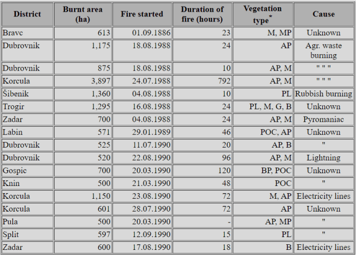
* M = maquis; MP = maritime pine; AP = aleppo pine; PL = pasture land; G = garrigue;
B =brushwood; POC = pubescent oak coppice
Tab. 4. Number of forest fires and burnt area in Croatia during the period 1971-1990.

Source: Forest Research Institute, Department of Forest Typology, and Ministry of Agriculture and Forestry.
From: Jela Bilandzija
Address:
Forest Research Institute
Department of Forest Typology
Streljacka 1
41000 Zagreb, Croatia
Phone/Fax: (++38) 41-42 65 40
