Forest fire damage in Athens quickly assessed with Definiens
Forest fire damage in Athens quickly assessed with Definiens
2 August 2007
published by www.gisuser.com
written by Definiens
www.definiens.com
The Aristotle University of Thessaloniki recently published studies revealing that over 5000 hectares of fir and pine forest in the Mount Parnitha National Park were destroyed by the recent forest fires.
Nearly half of the forested area surrounding the city of Athens, which was essential in coping with the pollution emitted by the capitals 2.5 million cars, is ruined. Detailed information about the burnt forest area was extracted with the Definiens Enterprise Image Intelligence Suite. The Aristotle University of Thessaloniki used the Definiens technology to analyze high resolution Ikonos satellite data in combination with a digital elevation model, resulting in very accurate and comprehensive maps about the area. The extent of the environmental damage causes scientists to warn of dire changes to the air quality and temperature of the city.
Forest fires are a major concern, both for environmental and safety reasons, therefore city authorities and government bodies must have complete and accurate information about these fires available quickly. The information is required to better understand the changes in the vegetation, the erosion and to determine the impact on wildlife as well as the duration of regeneration. A detailed report helps officials to gain a deeper understanding of the situation and to make the right decisions based on the best insights available. The information may also be used for subsequent forest renewal projects and subsidy management.
As dramatic and unfortunate it is, but natural disasters regrettably do happen. Therefore it is of utmost importance that officials have knowledge and insights to respond quickly in order to cope with the destruction, commented Rene Hermes, Definiens Vice President of Marketing. We are pleased to see the value of the Definiens technology in the management of natural resources and public safety.
In addition to the surface area of burnt forest, the Aristotle University of Thessaloniki generated valuable additional information. Using the Definiens Enterprise Image Intelligence Suite, they automatically assessed the distribution of islands of remaining forest within the large area. We required detailed and accurate results and insights of the Mount Parnitha forest area in a timely manner. The Definiens technology was critical in analyzing and evaluating the damage, said Ioannis Gitas, Lecturer at the Aristotle University of Thessaloniki.
Definiens in Earth Sciences
Definiens enables organizations involved in Earth Sciences to quickly extract accurate geo-information, ready for use in GIS, from earth observation and remote sensing imagery. Definiens intelligent feature extraction capabilities accelerate mapping, change detection as well as object recognition and deliver standardized, reproducible image analysisresults.

3D view of the Mount Parnitha forest fire damage. The dark area surrounded by a yellow outline represents the burnt area 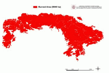
Overview of the Mount Parnitha forest fire damage 
Ikonos satellite image of the burnt area 
Ikonos satellite image of the burnt area with the burnt area highlighted in red
